
[click to enlarge]
Yosemite Falls
Photo by Ansel Adams
| Online Library: | Title | Author | California | Geology | History | Indians | Muir | Mountaineering | Nature | Management |
Yosemite > Library > Waterfalls > Yosemite Falls >
Next: Principal Waterfalls • Contents • Previous: Introduction
|
[click to enlarge] Yosemite Falls Photo by Ansel Adams |
Ranking with Half Dome and El Capitan in popular interest, this feature is perhaps most responsible for the world-wide fame enjoyed by Yosemite and thus is given special attention in this booklet. It was “the waterfall 1000 ft. high” that attracted the attention of James M. Hutchings. For many years the upper fall was considered the world’s highest free-leaping waterfall—a term applied in cases where the stream entirely clears the cliff over which it falls. More recent discoveries, however, have made it necessary to modify this statement since there is apparently a higher free-leaping fall in Venezuela. Nevertheless, Yosemite Falls ranks as one of the grandest and best known water spectacles in the world. From the standpoint of sheer’ dramatic beauty it has few rivals. The stream does not leap clear for the entire height of the upper fall for it “first cascades tumultuously about 70 ft. through a narrow chute worn in the rock face; then, bounding out, it describes a parabolic curve through space, clearing even the bulging lower part of the cliff, which projects more than 100 feet beyond the top” (Ref. 23). As the season wanes and the volume and force of the stream becomes appreciably less, the character of the free leap is reduced accordingly. Often, in the fall, following extended dry periods, Yosemite Creek is reduced to a comparative rivulet which occasionally is barely discernible as it descends the precipitous face of the cliff. It was on such an occasion that Horace Greeley, who visited Yosemite Valley in 1859, pronounced the vaunted magnificence of Yosemite Falls as “humbug.”

[click to enlarge] Half Dome from Sentinel Bridge |
Yosemite Falls may be viewed from a number of vantage points. Those that are available from highways have already been noted but it is from certain points along the Yosemite Falls Trail that one obtains a clearer and more satisfactory perspective of its majesty.
This trail leaves the floor of Yosemite Valley at Camp Four, a short distance west of Yosemite Lodge. By this means it is possible to ascend to the very brink of the falls after a hike of 3 1/2 miles, involving a climb of 2700 feet. Leaving Camp Four the trail climbs, via a series of switchbacks, to one of several natural horizontal ledges along the North Valley wall by means of which one proceeds to a point above the top of the lower fall. Here one finds himself directly in front of the massive precipice over which the upper fall drops, observing at close hand the magnificent plunge of the stream for a distance several hundred feet higher than the Empire State Building. As the water thunders into the rocky basin at the base of the gigantic precipice it gradually disperses into a broad fan, bathing the entire area in spray. The more concentrated portions erupt from the mass in a never-ending succession of comet-like “projectiles” which have an almost hypnotic effect upon the observer. In the rocky basin at the foot of the fall, which is several acres in extent, the stream again converges by means of numerous rivulets and sheets of water into a narrow gorge, through which it cascades boisterously to the brink of the second plunge of 320 feet, constituting the lower fall.
Continuing toward the base of the upper fall one finds a short spur trail bearing to the right, which affords an even more intimate approach. At its end, during periods of high water, one is buffeted by wind and spray but at other times it affords a pleasant and highly satisfactory viewpoint. Hikers should not proceed beyond the end of this spur trail. Slippery rocks above the gorge of Yosemite Creek are an ever-present danger. Returning to the main trail the climb is continued along a series of switchbacks that ascend through a narrow draw to the west of the fall. After reaching the rim an obscure trail leads to a narrow, rocky ledge (a metal handrail is available here) by means of which one descends to a natural rocky platform, protected by a metal railing. Here, at the very brink, one may observe the waters of Yosemite Creek leaping into space toward the rocky basin nearly a quarter of a mile below.
Due to the fluctuating volume of Yosemite Creek, the falls present a varying appearance at different

[click to enlarge] Yosemite Falls compared with Empire State Building |
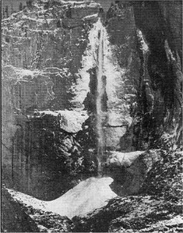
During the fall, as colder weather approaches, the spray which bathes the cliff freezes during the night to form a giant fan of ice on the granite —narrow at the top and widening to nearly 150 feet at the base. During the day, as the sun warms the cliff, the Yosemite basin reverberates with intermittent reports as great slabs of ice drop to its floor. As the winter progresses this accumulated ice, together with spray freezing on the cone, and snow and ice that is washed over the brink of the falls from above the rim, gathers to form the famous ice cone. Usually the cone reaches its maximum size by late March, and while it is generally 200-250 feet high, there have been times in past years when it reached even greater size. In February, 1937, the engineering department of Yosemite National Park made a survey of the ice cone. With the information obtained on this survey, calculations were made from a picture of an ice cone taken during the days of John Muir, which is probably one of the largest ever recorded. This study indicated that the height of the cone was 322 feet, its base occupied an area of 3.7 acres, and it contained a total volume of 25 million cu. ft. of ice and snow. Ice cones are formed in a similar manner at the base of all the waterfalls in Yosemite Valley, but none are as large nor as spectacular as this one.
On several occasions the ice cone has been studied at close hand in order to determine its character, which varies considerably from year to year. In February, 1933, its surface was so firmly frozen that steps had to be cut with an ice axe to facilitate an approach to within 20 feet of the top. In other years it has been easier to negotiate.
[click to enlarge] Yosemite Falls in Winter |
Incidentally, the ascent of the ice cone is not without considerable hazard. In addition to the danger of falling ice one often has to contend with the hazard of a considerable volume of water which not only falls with considerable force and soaks one to the skin, but presents an additional danger in that it undercuts the rear of the cone. Thus the topmost portion, being in the form of a cornice, might give way under one’s weight if the ascent to the actual top is successfully negotiated.
With the coming of warmer weather the ice cone gradually disappears. The water in the falls hastens the natural melting process (it generally has a temperature of over 32 degrees at that time), by continually washing the cone in an increasing volume. Usually by early April most of the cone has disintegrated.
The Lost Arrow section of the Valley floor in the vicinity of Yosemite Creek, between the base of the lower all and its junction with the Merced River, is often covered with a blanket of ice in the early spring. Since this generally occurs about the time of the disintegration of the ice cone the two phenomena are usually associated. However, they are not directly related. The ice flow is the result of climatic conditions which prompt a sudden increase in the size of Yosemite Creek, followed by a sudden drop in temperature. Thus great quantities of ice are produced as the water thunders over the successive drops from the rim to the Valley floor. In addition, snow from above the rim is washed over the brink by the stream. On the level floor of the Valley the retarded flow of Yosemite Creek possesses a force insufficient to carry the burden of ice away and, as a consequence, it is deposited along its banks and spread out over the adjoining level areas. On April 19, 1933, thirty-three acres in that region were covered in that fashion with snow and ice to a maximum depth of five feet.

[click to enlarge] Ice Cone of Yosemite Falls, February, 1932 |
Next: Principal Waterfalls • Contents • Previous: Introduction
| Online Library: | Title | Author | California | Geology | History | Indians | Muir | Mountaineering | Nature | Management |
http://www.yosemite.ca.us/library/waterfalls/yosemite_falls.html