Home | A - Z | FAQ | Bookstore | Art Prints | Online Library | Discussion Forum | Muir | Weather | Maps | Lodging | About | Search |
CalHotels.US
Lowest Hotel Rates Guaranteed.
Click Here For Yours!
Hotel photos, maps, reviews, & discount rates. U.S. Hotels in California (Yosemite, L. A., San Francisco ), AL, AK, AR, AS, AZ, CA, CO, CT, DC, DE, FL, FM, GA, GU, HI, ID, IL, IN, IA, KS, KY, LA, ME, MD, MA, MI, MN, MS, MO, MT, NE, NH, NJ, NY, OK, NV, MH, MP, NM, NC, ND, OH, OR, PA, PR, PW, RI, SC, SD, TN, TX, UT, VT, VA, VI WA, WV, WI, WY |
Phil wrote:You kind of go in stages. From GA to to the crossing at Cathedral Creek is a slight incline that rolls up and down within about a couple hundred feet. Nothing too steep except the first part of the trail from the junction down below White Cascade and up to McGee Lake. From Cathedral Creek is where the only real climb is, and it begins to climb fairly steeply up to about 8400 within about 3/4-1 mile. Most of your vertical gain is here. You then go into a gentle uphill for about another 300 ft of gain at the Murphy Creek junction. More of the same for the next mile and a half or so when you reach a set of exposed switchbacks that take you to the top of, for lack of a name, the pass above Raisin Lake at about 9000 ft. From there it's a gentle downhill for about another 1/4 mile or so to the lake at about 8900. Most of the route is deeply shaded with a few exceptions, those switchbacks being one of them. So all said and done you end up with about 1000 ft of overall gain in about 6-ish miles. Not bad at all, and not even close to how hot and miserable that climb is up from Tenaya Lake to the Sunrise/CR junction.
And you know, unless you have a hankering to see May Lake, and if you want to get in some cross-country practice that's manageable and safe enough with gentle and open terrain, and save a couple miles and some climbing in the process, you can follow the drainage or head to the SE from Raisin Lake and hit Tioga Rd down by Sunrise more quickly.
EdelKev wrote:
Hey now that I have a hike plan in mind I'm thinking about food. We have a BV500 cannister but I'm wondering if that will be big enough for five nights for two. I guess we can pack our Day 1 food outside the cannister, but that leaves four nights for two. Its been so long since our last trip I've lost all sense of foodplanning and packing. Assuming MH meals for dinners, tuna/tortillas for lunch and oatmeal for breakfast, and snacks, and if it turns out 4 days/nights for 2 doesn't fit, I've heard it's OK to stash food at Bearbox YE02 at Tenyaya Lake to pick up on the way up to Sunrise. Is this right, and would experienced hikers stash food at YE02 (i.e. its a more public box than a HSC box, it would be a real burn if the food wasnt there when we hit Tioga). Is there much bear activity at/near the GA HSC? Thanks...I know I may be "overthinking" and all the food will probably fit, but I'd like to be as foodsmart as possible while following all of the rules.
EdelKev wrote:Phil: You. Da. Man. !!! Thanks again (again) for the awesome intel. I'm way too embarrassed to admit the insane amount of water I packed up the trail on our first time up to Sunrise from Tenaya Lake, so having good knowledge about hydration points and the right amount of water to pack on the GA-May lake leg is a huge load off my mind (and back)!!
How is the elevation gain from GA to Raisin lake? Is the strenuousness of that hike comparable to the hike up to Sunrise? Based on your comments I'm liking the thought of camping at Raisin Lake and then going through to Sunrise on the next hiking day.
Thanks again!
Paddy wrote:Here is my trip report if you want to get an idea.
https://sites.google.com/site/myownway2 ... unrise-hsc
Phil wrote:I don't carry a BV, but 700ci is supposed to be good for 7 days of food for one person. With MH meals, you can always repackage to pick up space. Test load it at home. But, I would go ahead and stash the food for my second leg at Sunrise, just to save weight, especially since you're going past there on the way to Tuolumne anyhow. It's rare when people mess with it, and there are half a dozen or more lockers down there, so squeaking in your stuff shouldn't be a problem. Just don't leave it in anything nice, and just use a crappy bag or beat up stuff sack to store it in.
Bears are everywhere, but I've never heard of them being an exceptional problem at GA. Raisin Lake, I've never had a problem. May Lake, not unheard of. Sunrise Lakes/HSC, don't be surprised at all. Same with Cathedral Lakes. They're really nothing to worry about if you keep your food and toiletries tight. No worries...they're actually kind of fun to watch beating your can around, as long as they're not getting into it.
When you get your map, have a look at that xc route down from Raisin Lake, and remember that with the Harrison map, those are 80 foot contour intervals. It's roughly just a little over a mile, but it's open slabs and lightly forested, and even if you get "lost", it's one of those places where you'll eventually stop out at the road somewhere if you keep going downhill. Your wife might be nervous about not following the trail, but she'll be stoked when it works out, and it's virtually a given. It's sort of a unique thing...a little extra adventure within the adventure. And, she'll think that "You. Da. Man."
Phil wrote:
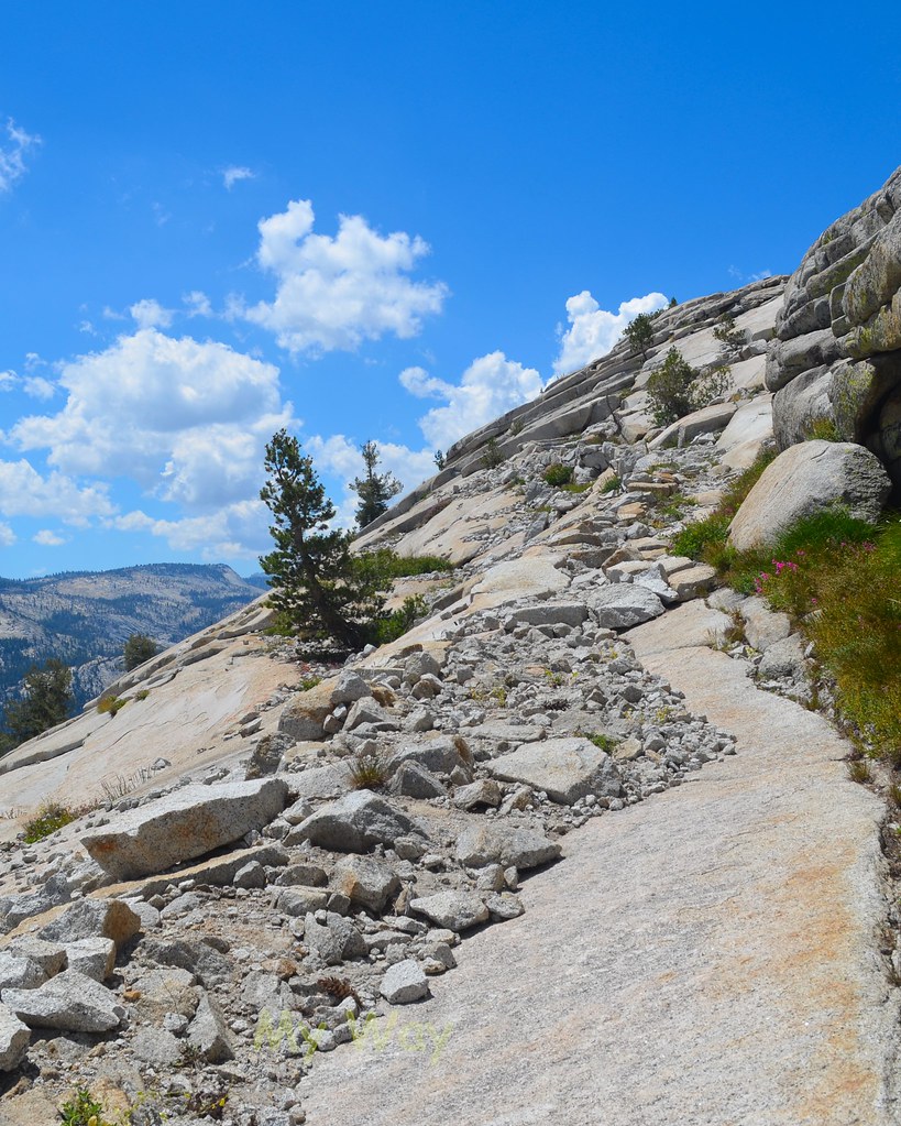
Yeah, I enjoyed Paddy's TR too (thanks Paddy). I may be mistaken, but I believe that photo is of the switchbacks headed up to the pass right before Raisin Lake. The cross-slope looks familiar, although the last time I did it it was covered in snow and pouring rain. You can see that it's pretty exposed, and if you do decide to go up to May Lake, you can expect another stretch, just without the cross-slope, but you get some idea of what to expect.
.
Return to Yosemite Hiking & Backpacking
Users browsing this forum: No registered users and 11 guests