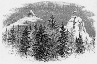
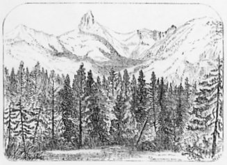
GRANITE ROCKS NEAR CAMP 169.
| Online Library: | Title | Author | California | Geology | History | Indians | Muir | Mountaineering | Nature | Management |
Yosemite > Library > Yosemite Guide-Book > High Sierra >
Next: Chapter 5: The Big Trees • Index • Previous: Chapter 4: The High Sierra
[Editors Note: The following text did not appear in the original 1869 edition of The Yosemite Book. It was appended to the end of Chapter 4 in the next edition, The Yosemite Guide-Book (1870). This additional material covers further explorations the California Geological Survey made of the High Sierra, including the southern Sierra Nevada.]
This chapter may be closed by adding a few pages in regard to a portion of the High Sierra beyond the limits of the map accompanying this volume, but to which we desire to direct attention, as including the loftiest and the grandest mountains, and the most stupendous mountain scenery, yet discovered within our own territory.
By referring to the Table on page 37, it will be observed that between latitudes 36° and 37° there are peaks and passes higher than those described as existing near the Yosemite, there being a general rise of the mass of the Sierra as we go south. This high region, in which the passes exceed 12,000, and the peaks rise, in one instance at least, to 15,000 feet, lies at the head of King’s and Kern rivers and the San Joaquin. The most elevated peaks are between the parallels of 36° 30’ and 37°, and are distant from the Yosemite, in a southeast direction, from 90 to 110 miles. This region was first explored by the Geological Survey in 1864, and a synopsis of the results of this reconnaissance will be found in the “Geology of Califorina,” Vol. 1. (pp. 365-402), from which some extracts will here he introduced, in the hope of attracting the attention of some travellers, who may thus be induced to push their explorations beyond the comparatively narrow limits of a trip to and around the Yosemite. The region in question is not very difficult of access; indeed, a very good idea of its grandeur may be obtained by only a short trip from Visalia and back.
Our party, consisting of Messrs. Brewer, Hoffmann, King, Gardner, and Cotter, took the field in May and proceeded from San Francisco across the plains of the San Joaquin to Visalia, from which point they entered the Sierra, ascending King’s River to its source, and exploring the whole region about the head-waters of that and Kern River. Thence they made their way across the range by a pass over 12,000 feet high, passed up Owen’s Valley, ascended the west branch of Owen’s River, crossing the Sierra again at an altitude of 12,400 feet, and thence descending to the head of the San Joaquin River. The exploration was continued through the region of the head-waters of that stream and the Merced, connecting the reconnaissance with that of 1863 around the sources of the Tuolumne. The whole expedition occupied about three months, during which time the geography and district including an area of over 10,000 square miles were for the first time explored, the whole region having previously been entirely unknown. The results proved to be of the greatest interest, disclosing the fact that this was the highest part of the Sierra Nevada, which was something quite unexpected to most persons, Mount Shasta having long been considered the most elevated point in California.
Thomas’s Saw-mill (Camp 164), at an elevation of 6,484 feet above the sea, and about forty miles northeast of Visalia, may be made the base of supplies for an expedition to this region. The mill stands on the edge of a beautiful meadow, the water from which runs into King’s River. It is surrounded by a magnificent forest of the usual coniferous trees found in the Sierra at this altitude, and a little higher up the Big Trees (Sequoia gigantea) are abundant, as will be noticed in the next chapter.
A rocky summit, called Bald Mountain, about six miles east of Thomas’s Hill, was ascended by our party for the purpose of getting the first idea of the topography of the unknown region about to be visited. It is easy of access, although 7,936 feet high, and offers a fine view of the neighboring country and the extended crest of the Sierra. Its position is at once seen to be on the great elevated divide between the waters of King’s River on the north, and the Kaweah on the south. This divide runs up to the snowy mountains at the summit of the chain, and appeared to terminate in the highest group of peaks, some twenty-five or thirty miles distant. The ridge of the divide rises at intervals into peaks, each one commanding the country on either side and behind it, as well as forward to the east as far as the next high point in that direction. About eight or nine miles to the north, and several thousand feet below, is the cañon of King’s River, which seems precipitous and impassable. Some twenty miles to the northeast this river divides into two branches, and the course of the northern of these is such that the observer on the summit of Bald Mountain can look directly into it. The view is most impressive. Granite walls with buttresses, pinnacles, and domes rise perpendicularly from three to five thousand feet above the river, and above these the bare, rocky slopes tower up, high above all vegetation into regions of perpetual snow. Dark lines of trees wind up the ravines on the mountain-sides, becoming thinner and more scattered, until they disappear altogether, the summits of the mountains rising far above all vegetation, barren and desolate.
Such is the character of the divide between the main forks of the King’s River, although the southern side is not as steep as the northern. Its lofty summit, everywhere crested with precipices, prevented an insurmountable barrier, over which our party never succeeded in taking their animals. Just at the junction of the forks, the end of the divide is crossed by a broad red stripe, bearing about northwest, and which could be seen appearing again on the north side of the cañon. This, which seemed to be a great dyke of volcanic rock, but which was afterwards found to be a vein of granite, led to giving the divide the name of “Dyke Ridge.”
An attempt was first made to reach the summit of the Sierra by travelling up this divide, an old Indian trail being discovered which was followed for about fifteen miles. This trail led to a point where the ridge widened out into a plateau occupied by a large meadow; a number of cattle had been driven here, and the place was known to hunters as the “Big Meadows.” Camp 165 was intermediate between Thomas’s and the Big Meadows, and was 7,450 feet above the sea. The rock along the whole route is granite, which has a tendency to weather into grand, rounded, boulder-like masses. Camp 166, about two miles below fire Big Meadows, but nearly at the same altitude, was at an elevation of 7,827 feet. Here the massive granite is traversed by occasional dykes of a fine-grained variety of the same rock, and with veins of milky quartz. Large areas of nearly level or gently-sloping ground occur here, covered with meadows or forests of Pinus contorta, and there are also extensive patches of bare rock, or of granitic sand derived from its decomposition. As the granite decomposes very irregularly, the harder portions rise in rocky, rounded hills, and the softer are occupied by small valleys. A series of these grassy flats, five or six miles in length, makes up the Big Meadows, and they are drained in both directions, namely, into the King’s and Kaweah rivers. At this altitude the sugar and pitch pines, as well as the Big Trees, are left behind, and the forests are made up of the dark and sombre fir and Pinus contorta. Although it was the mouth of June, the thermometer sank as low as 16° at night, and a snow-storm of three or four hours’ duration occurred.
Just east of the Big Meadows, and on the summit of the divide, are two elevations, to which the name of “Dome Mountains” was given, from the finely rounded, dome-like sweep of their outlines, which contrasts in a striking manner with the sharpness of the summit peaks behind them. On their southern sides the forests rise in an unbroken curve to their summits; but on the north side there is a precipice for 200 to 300 feet below the crest, then a short, concave curve, and then the rounded and wooded slope descending to the King’s River Valley. In this part of the mountains, as at the Yosemite, the granite exhibits a tendency to form dome-shaped masses on a grand scale; but on the very crest or summit-range it rises in pinnacles, giving a very different character to the scenery, as will be noticed further on. That one of these Dome Mountains which was ascended was found to be 9,825 feet high. Its summit was made up of concentric layers or beds of granite, from one to five feet thick, breaking into large rectangular masses sufficiently smooth and regular in form to be used for masonry without dressing. The north slope of the mountain is covered by immense masses of this angular débris. That this concentric structure is not the result of the original stratification of the rock, is evident from a study of the phenomena, which do not indicate anything like anticlinal or synclinal axes, or any irregular folding. The curves are arranged strictly with reference to the surface of the in masses of rock, showing clearly that they must have been produced by the contraction of the material while cooling or solidifying, and also giving very strongly the impression that, in many places, we see something of the original shape of the surface, as it was when the granitic mass assumed its present position. In the cañons between these domes we sometimes have large surfaces exposed by denudation, and, as a result of the original concentric structure of the rocks on each side, we see the great plates of granite overlapping each other, and where considerable weathering and denudation has taken place, we have picturesque and curious forms as the result; pyramids and pinnacles are left standing on the prominent points, and their bedded structure adds to the peculiar impression which they give of their being works of art rather than of nature. Fig. 14 will serve to illustrate the kind of scenery which is common in the region of this concentrically bedded granite.
|
Fig. 14.
GRANITE ROCKS NEAR CAMP 169. |
The route followed by the party, in their attempt to reach the summit, led around the north side of the Domes, over the huge piles of angular fragments, and was on this account tedious and difficult. Camp 167 was made at a point two miles northeast of the Dome, and at an altitude of 8,890 feet above the sea. Camp 168 was four or five miles southeast of the Dome, at a small meadow on the divide, and at an elevation of 9,569 feet. Progress was necessarily very slow, owing to the heavy load of provisions and instruments with which the small train of animals was packed, and the extreme roughness of the region travelled over. Beyond the Domes the divide contracts to a mere ridge; the slope to the south, although steep, is comparatively smooth, and spreads out, towards its base, into rolling wooded spurs, between which small brooks run down into the Kaweab. Nearly all these streams head in little sedgy meadows, whose bright green contrasts beautifully with the deep shade of the surrounding forests. To the north, the aspect of things was different; instead of a smooth slope, there was a fractured granite precipice, descending 200 feet, then a slope of ddébris, and at its foot two small lakes, forming the head-waters of a stream which unites with the south fork of King’s River, a few miles above the dyke. This stream was called Glacier Brook, from the abundant traces of former glacial action in its vicinity. From Camp 168 to the Big Meadows is only sixteen miles; but so difficult was the way, that it required two days for the party to accomplish that distance. From this camp, and the next (No. 169), two miles farther up the divide, an examination was made of an interesting and characteristic feature in the topography of this granitic region, and to which the name of “The Kettle” was given.
This is a rocky amphitheatre at the head of a stream which flows back directly northeast from its source towards the axis of the chain, for a distance of twelve miles, and then curves and enters King’s River, a peculiar and almost unique course for a stream in the Sierra Nevada. The kettle-like form of the head of this valley may be seen from the annexed section across
Fig. 15.
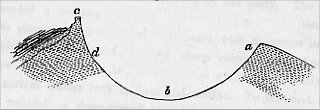
SECTION OF THE KETTLE. |
The northern rim (a) is about 1,100 feet above the bottom (b); the southern one (c) rises in a sharp ridge 1,606 feet above b; in some places c d is a little less than a mile. The Kettle is open at the north-northeast end, and extends as a green valley some six miles, to the south fork of King’s River. There are several small domes and pinnacles on the east side, and in some places the granite along the rim forms a parapet, which has a striking resemblance to an artificial structure, as the rock is most beautifully and regularly bedded, so that the wall seems to vie with the most finished mason-work in execution. The annexed woodcut (Fig. 16) will show the exact appearance of a portion of this wall, which is in some places so thin that the light can be shining through between the cracks. It is rom eight to twenty feet high.
Fig. 16.
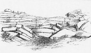
RIM OF THE KETTLE. |
This rim of the Kettle is a beautiful illustration of the concentric or “dome-structure” of the granite of this region. The dotted lines in Fig. 15 show the bedding or lamination of the rock, in the cross-section of the whole, and Fig. 17 explains how the parapet has been formed by the wearing away of a part of the concentrically-laminated granite near the summit. This peculiar crater-like cavity in the granite is typical of many others seen afterwards in this region, the origin of which it seems impossible to refer to any ordinary denudation, or to the action of glaciers. These cavities were all occupied by in masses of ice, as is evident from the polish of the interior walls and bottom of each of them; but it hardly needs to be added that no glacial action could have originally formed one of these kettles; the most that it could do would he to scour out and polish up the interior. This subject will be discussed in the second volume of the “Geology of California.”
Fig. 17.
![Fig. 17. [Parapet of the Kettle.]](images/figure_17.jpg)
|
Beyond the Kettle the divide becomes quite impassable for animals, and nearly so for men. Several unsuccessful trials were made to pass the barrier of nearly perpendicular rocks; but, at last, a chink in the granite was found, through which the party crawled, and proceeded to ascend the next high peak on the divide, which is about six miles southeast of Camp 169, the elevation of which was found to be 11,623 feet above the sea. From its summit a magnificent view was obtained of the crest of the Sierra, as well as of the divide which had been traversed by the party. The region to the east presented a complicated system of very sharp ridges, rising here and there into pinnacles, apparently all of granite, with numerous immense circular amphitheatral cavities, formed by sharp ridges surrounding basins, of which one side is always broken away, and which have exactly the appearance of ancient craters both in form and outline. To the west the predominance of rounded or dome-shaped mountain summits was most striking, the whole country appearing as if it had suddenly been cooled or congealed while violently boiling.
Camp 170 was about seven miles north-northeast of No. 169, in the valley of the stream which flows from the Kettle, and at an altitude of 7,408 feet, which was a lower point than was afterwards reached by the party for a long time. The way to this camp led around the west and north sides of the Kettle over a region exceedingly difficult to traverse, with alternating steep, naked slopes of granite, and thick, low forests. Some of the ancient moraines, piles of angular fragments of granite, were almost insurmountable obstacles to the passage of the animals. This camp was situated behind a sharp granite knob which rises from the valley like a sugar-loaf, as seen from below; but which, in reality, is the end of a ridge a mile or two in length. This is several hundred feet high, and its summit is quite inaccessible. Its sides show undoubted evidence that it was once surrounded by a great glacier flowing down the valley. The slopes directed towards the moving ice are worn and polished, and huge boulders have been pushed up on them, and left all along, wherever the angle was not too steep for fragments of rock to lie. The meadow occupies a basin behind this knob, which appears to have been scooped out by a glacier.
From the Sugar Loaf Rock there is a magnificent view up the valley to the group of mountains forming the western crest of the Sierra, the culminating point of which was named Mount Brewer. This was directly east, and about ten miles distant. A grand view was also had of the great moraine on the eastern side of the extreme south fork of King’s River; this moraine stretches along for six or eight miles in an unbroken line, resembling an immense artificial embankment. There is another one on the opposite side of the valley which is also very distinct, but the eastern one is much the larger. The horizontal distance across from one to the other is about a mile and a half. At a distance these moraines appear as regular as railroad embankments, their crests being quite smooth, and having a uniform and gradual inclination up the valley. To ascend or descend their sides with animals, is a task of considerable difficulty but, once on the top, travelling is quite easy. In the bottom of the valley the granite is everywhere grooved and beautifully polished.
The view of the cañon, towards its head, as seen from this moraine, near Camp 175, was sublime, strongly resembling the valley of the Yosemite in some of its gradest features. It curves but little, so that the view is unobstructed. Great surfaces and precipices of naked granite are seen, often over 1,000 feet high, but seldom vertical, although sloping at a very high angle; these surfaces are everywhere in the valley rounded and polished. Side cañons of the same character but still more precipitous, open into the main one.
From Camp 171, Mount Brewer was twice ascended, on the 2d and 4th of July, by passing up the valley in which the camp was situated, and which divides at the base of the mountain, extending up to the crest of the ridge. Its sides were found to be very steep up to above 12,000 feet, the southern one being an almost vertical wall of 1,000 feet in height. The granite of this region is hard, not very coarse, and of a light ash-gray color, with a pearly lustre when seen in great masses. It is intersected with veins
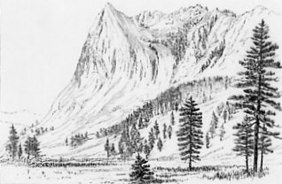
Fig. 18.
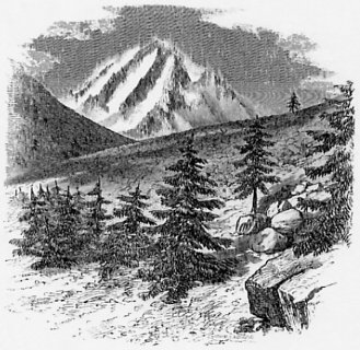
MOUNT BREWER, FROM A POINT THREE MILES DISTANT, LOOKING EAST. |
The view from the summit of Mount Brewer is one of the most sublime which it is possible to obtain, even in this sublimest portion of the Sierra. The snowy peaks, rising to over 11,000 feet in elevation, cover a breadth of more than twenty-five miles, and the point of view on the summit of this mountain is such, that the observer is placed in the very midst of this grand assemblage. High peaks, sharp ridges bristling with pinnacles, rocky amphitheatres, and deep cañons constitute the main features of the scene. The summit is a loose and shattered mass of angular pieces of granite, forming a ridge some thirty feet long by five broad, which from the west appears as a sharp cone. The eastern side of the mountain is a precipice buttressed by a thin ridge, running out between two great vertically-walled basins, white with snow, which contrasts beautifully with the vivid blue of the frozen lakes 3,000 feet below.
The barometrical measurements make the height of Mount Brewer 13,556 feet; it is not, however, the culminating point of the Sierra, but is on a spur embraced by two branches of King’s River. Ten miles farther east another ridge stretches in an unbroken line north and south, and through its depressions the blue ranges of the desert are plainly seen. On this ridge there are fourteen peaks visible, ten of which are as high as Mount Brewer, and four higher. One of these, directly opposite, and which appeared to be the highest point but one, was called Mount Tyndall, in honor of this distinguished physicist and alpine explorer. The other high point, eight miles south of Mount Tyndall, and, so far as known, the culminating peak of the Sierra, was named by the party Mount Whitney. Farther observations, by Mr. King, showed that a point about two miles northeast of Mount Tyndall was a little higher than this mountain; it was named in honor of Major R. S. Williamson, of the United States Engineers, so well known by his topographical labors on the Pacific coast, especially in connection with the United States railroad surveys. Thirty-two miles north-northwest is a very high mountain, called Mount Goddard, in honor of a Civil Engineer who has done much to advance our knowledge of the geography of California, and who is the author of “Britton and Rey’s Map.” A transverse ridge running obliquely across from Mount Brewer to Mount Tyndall forms the divide between the head-waters of the Kern and those of King’s River. South of this, the division of the summit of the Sierra into two parallel ridges is very marked, the Kern flowing in the tremendous gorge between them. The eastern ridge forms an almost unbroken wall for a great distance to the north, while the western one is less distinctly marked, being broken through to allow of the passage of the head-waters of the King’s and San Joaquin rivers. The highest portion of the western ridge is that extending between Mount Brewer and Kaweab Peak, twelve miles to the south. This last-named peak was not reached by our party, but its height was estimated to be over 14,000 feet. From its great elevation and peculiar position, opposite to the highest point of the Sierra, and the immense depth of the cañon of the Kern between it and Mount Whitney, it would probably command the grandest view which could be obtained in the whole range of the Sierra. Kaweab Peak is distinctly visible from Visalia, to one looking up the valley of the Kaweab River.
Of the terrible grandeur of the region embraced in this portion of the Sierra it is hardly possible to convey any idea. Mr. Gardner, in his notes of the view from Mount Brewer, thus enumerates some of the most striking features of the scene: “Cañons from two to five thousand feet deep, between thin ridges topped with pinnacles sharp as needles; successions of great, crater-like amphitheatres, with crowning precipices over sweeping snow-fields and frozen lakes; everywhere naked and shattered granite without a sign of vegetation, except where a few gnarled and storm-beaten pines (Pinus contorta, P. albicaulis, and P. aristata) cling to the rocks in the deeper cañons; such were the elements of the scene we looked down upon, while cold gray deeds were drifting overhead.”
The upper part of the mountain slopes rapidly on all sides for 2,000 feet from the summit, then falls off more gradually on the west towards the cañon of the south fork of King’s River. On the east, it breaks off suddenly into a great amphitheatre, the head of a cañon between 4,000 and 5,000 feet deep below the crest, surrounded by sheer vertical walls, and with glacier-polished slopes at the bottom, over which are scattered several small and beautiful lakes. These cañons and precipices, which lie between the two principal ridges, constitute the main difficulty in reaching and exploring the eastern summit peaks. The region is desolate and cold; but these hindrances, incidental to all high mountain climbing, could be overcome, were it not for the impassable precipices which continually block the way, necessitating long détours, and rendering it impossible to reach any high peak without a long series of perilous and extremely fatiguing ascents and descents.
As want of provisions and the absolute impossibility of proceeding any further with the animals were sufficient reasons to prevent the whole party from making any attempt to climb the summit of the eastern ridge, Mr. King volunteered to undertake this task, although it seemed to most of the party that it was quite impossible to reach either of the highest peaks from the western side. Packing provisions for six days and one blanket, he started, accompanied by Richard Cotter, from the camp at the base of Mount Brewer, July 4th, and the following account of the trip, in which the summit of Mount Tyndall was reached, is given nearly in Mr. King’s own words:—
“To follow down the ridge which forms the divide between King’s and Kern rivers, and which runs obliquely across from Mount Brewer to Mount Tyndall, was impossible, for it rose in sharp crags above us, and had we been able to pass around these, we should have been stopped by vertical clefts over a thousand feet deep. We began, therefore, to climb down the eastern slope of the ridge, instead of trying to keep on its crest. The only way down was along a sloping shelf, on which we were obliged to proceed with the greatest caution, as our packs had a constant tendency to overbalance us, and a single misstep would have been fatal. At last we reached the base of the cliff safely, and made our way rapidly down a long snow-slope and over huge angular in masses of débris to the margin of a frozen lake.
“We were now in the amphitheatre; the crags towering around us were all inaccessible, and we were obliged to spend six hours in climbing down from the outlet of the lake, over a slope of smooth granite, polished by glaciers, and kept constantly wet by a shallow current of water, into King’s River Cañon, and then up again over a long, difficult débris slope and across several fields of snow, into another amphitheatre. Of this the southern wall is the divide between King’s and Kern rivers. The sky by this time had become quite overcast, and we were obliged to take refuge under some overhanging rocks, while a severe hail-storm went by. We started on again, hoping to cross over to Kern Cañon but the ascent proved very difficult, and night overtook us at the foot of a cliff 2,000 feet high. There was no wood, so we burned paper and dead carices enough to make some lukewarm tea, and finding a crevice among the ice and granite blocks, somewhat sheltered from the biting winds, we retired. The elevation was over 12,000 feet, and the air stinging cold; but the sunset view was glorious. The east wall of the basin was brilliantly lighted up, its hundred pinnacles were of pure yellow, relieved by the dark blue of the sky, which is so noticeable when one looks up from a deep cañon in the Sierra. A long slope of snow opposite us warmed with a soft rosy tinge (the Alpine glow), and the rugged ridge behind us cast a serrated gray shadow across it, which slowly crept up and scaled the granite wall, until only the very topmost spires were in the light. All night long, large masses of granite came crashing down from the crags overhead, striking at times too near for comfort.
“The next morning we ate our frozen venison by starlight, and started at sunrise to ascend the snow-slope before it should become softened. we had to cut steps, and after working up awhile it became quite difficult, so that we were three hours in reaching the rocks, after which we climbed two hours more, until we came to a very bad ravine where it was impossible to proceed with our packs. It was now that our reata came into play, and we took turns in climbing the length of it, and pulling packs and blankets after us, reaching the top about noon, by which time the novelty of this method of ascent had quite worn off. What was our consternation to find ourselves, as we scaled the summit, on the brink of an almost Yosemite cliff! We walked along the edge, however, for some distance, until at last we discovered three shelves, each about fifty feet below the other, from the lowest of which we might, by good luck and hard climbing, work along the face of the cliff to a sort of ravine, down which we might probably reach the débris. I tied the reata firmly about me body, and Cotter lowered me down to the first shelf; he then carefully sent down the precious barometer and our packs. Next, he made a fast loop in the lasso, hooked it over a point of rock and came down hand over hand, whipping the rope off the rock to which it had been fastened, thus severing our communication with the top of the cliff. This operation was repeated, not without considerable danger, from the impossibility of finding a firm rock around which to secure the rope, until the bottom was at last safely reached. At the foot of the débris was a beautiful lake half a mile long, once the bottom of the bed of a glacier.
“There were a few Pinus contorta visible down the course of the Kern,—here only a small brook,—and quite a grove of P. aristata; these, with a few willows and an Alpine Ribes, were all the vegetation we could see, excepting a few carices. Camp was made at the base of the peak, after climbing up a difficult ridge, near a little cluster of the Pinus contorta; this was about 11,000 feet above the sea.
“The next day the summit was reached, without serious difficulty, after some risky climbing of smooth dome-shaped masses of granite, where the only support and aid in climbing was an occasional crack. The barometer stood, at 12 M., at 18.104, the temperature of the air being 44°. On setting the level, it was seen at once that there were two peaks equally high in sight, and two still more elevated, all within a distance of seven miles. Of the two highest, one rose close by, hardly a mile away; it is an inaccessible bunch of needles, and we gave it the name of Mount Williamson. The other, which we called Mount Whitney, appeared especially inaccessible from any point on the north or west side; it is between seven and eight miles distant, in a south-southeast direction, and I should think fully 350 feet higher than our peak. (Farther examination showed that it was really 600 or 700 feet higher than Mount Tyndall.) Within our field of view were five mountains over 14,000 feet, and about fifty peaks over 13,000.
“The five highest peaks are all on the eastern ridge. Owen’s Valley, a brown sage plain, lies 10,000 feet below on the one side, and Kern Cañon, once the rocky bed of a grand old glacier, 4,000 feet down on the other. About fifteen miles north of here, King’s River cuts through the western ridge and turns at a right angle towards the plain. North of this point, again, the two great ridges unite in a grand pile of granite mountains, whose outlines are all of the most rugged and fantastic character. Twenty-five miles south, the high ground ends, there (certainly for a breadth of sixty miles) forming one broad, rolling, forest-covered plateau, 8,000 to 9,000 feet in elevation.
“From Mount Brewer to Kaweah Peak, the two culminating points of the western ridge, for a distance of fifteen miles, there is nothing that can be called a separate mountain; it is, rather, a great mural ridge, capped by small sharp cones and low, ragged domes, all covered with little minarets. At one place the ridge forms a level table upon this lies an unbroken cover of snow. To the eastward, all this range, from King’s River gateway to Kaweah Peak, presents a series of blank, almost perpendicular precipices, broken every mile or so by a bold granite buttress. Between these are vast snow-fields, and also numberless deep lakes, of which the most elevated are frozen.”
The elevation of Mount Tyndall, as calculated from Mr. King’s observations, compared with those of the other party, and with the station barometer at Visalia, was fixed at 14,386 feet; this is only fifty-four feet less than the altitude of Mount Shasta.
After Mr. King’s return to Camp 171, at the eastern base of Mount Brewer, the whole pary went back to Big Meadows, having been out of provisions for several days, with the exception of a few strips of jerked bear meat. Here, also, they were to meet the escort which was considered indispensable for safely exploring the region to the north. Mr. King, however, not being satisfied with his first attempt to reach the culminating point of the Sierra, made another start from Visalia July 14th, with no other company than an escort of two soldiers. His intention was to follow the Owen’s Lake and Visalia trail, which leads up the Kaweah River, keeping the south fork from its junction with the main river. It was supposed that it might be possible to reach the summit of Mount Whitney from this side, previous explorations having shown that this could not be accomplished from the northwest or west.
The first camp was at forty miles distance from the edge of the foot-hills, the road up the valley being intensely hot, dry, and dusty. From this camp the trail led over a rolling plateau of high altitude (probably between 8,000 and 9,000 feet), partly covered by forests of Pinus contorta, and partly by chains of meadows. North of the road was a range of bald, granite hills, with groves of pine scattered about their bases, an occasional patch of snow appearing on the higher points. This chain of peaks seems to be the continuation of the divide between the south and main Kaweab rivers, and it continues eastward to the summit of the Sierra, being the southern termination of the high ranges to the north; south of it the country falls off gradually to Walker’s Pass, forming numerous broad, flat-topped ridges, which give the region the general aspect of a table-land, scored down from north to south by parallel cañons, of which the Kern occupies the deepest. The main and north forks of this river rise far to the north of this table-land, and cut their way through it, while the south fork heads on its southern slope, and joins the main river, about eight miles below where the trail crosses. This plateau is entirely of granite, and the vegetation varies according to the altitude. West of the cañon of the south fork, the forests are chiefly of the Pinus contorta; between this and the main Kern are fine groves of P. Jeffreyi, and occasional oaks. Where the trail crosses the main Kern, the river is twenty-five or thirty yards wide; the water is clear and cold, and abundantly supplied with trout.
From this point the old trail bent southward, crossing the mountains some distance below Little Owen’s Lake; the new one was built no farther, and from here it was necessary to continue the exploration, without any other guides than the eye and the compass. Striking the north fork of the Kern, at that point only a brook four or five yards wide, Mr. King followed it up for several miles, to where it breaks through an east and west range of craggy peaks, which comes down like an immense spur at right-angles to the general course of the Sierra, and is continued as an elevated ridge far down the north side of the Kaweab. This range heads in a very high and bare granitic peak, called Sheep Rock, from the great number of mountain sheep found in this vicinity. It is about eight miles south of Mount Whitney, and is the termination of this high portion of the Sierra.
North of this spur or lateral range through which the north and main forks of the Kern both make their way, there is a quadrilateral area, comprised between the two great divisions of the Sierra on the east and west sides, and having on the north the transverse ridge which connects Mount Tyndall with Mount Whitney. In this the main Kern heads with in many branches, and to the east of it, in the midst of every difficulty, Mr. King worked for three days before he could reach the base of the mountain, whose summit he was endeavoring to attain. All his efforts, however, proved unsuccessful, so far as this particular object was concerned; but he was enabled to determine the main features of the topography of a considerable area, which otherwise would necessarily have been left an entire blank upon our map. The highest point reached by him was, according to the most reliable calculations, 14,740 feet above the sea-level. At the place where this observation was taken he was, as near as he was able to estimate, between 300 and 400 feet lower than the culminating point of the mountain, which must, therefore, somewhat exceed 15,000 feet in height.
The summit is a ridge having somewhat the outline of a helmet, the perpendicular face being turned towards the east, and there is snow on its summit, which indicates that there must be a flat surface there. It is the culminating point of an immense pile of granite, which is cut almost to the centre by numerous steep and often almost vertical cañons, ending in high walled amphitheatres. Southward of the main peak there is a range of sharp needles, four of which are over 14,000 feet high. The general aspect of the group is much like that of Mount Tyndall. Mount Whitney has been approached on all sides, except from the east, and, so far, found to he utterly inaccessible.
During the time while Mr. King was exploring about the sources of Kern River, Professor Brewer and party continued their route northward, in the hope of being able to cross over the higher ridges of the Sierra to the head of the San Joaquin. They left the Big Meadows and made their way into the great cañon of the south fork of King’s River by a terribly steep road, the descent being between 4,500 and 5,000 feet. The cañon here is very much like the Yosemite. It is a valley, from half a mile to a mile wide at the bottoms, about eleven miles long, and closed at the lower end by a deep and inaccessible ravine like that below the Yosemite, but deeper and more precipitous. It expands above and branches at its head, and is everywhere surrounded and walled in by grand precipices, broken here and there by side cañons, resembling the Yosemite in its main features. The walls of the King’s River Cañon, however, are nowhere vertical to so great a height as El Capitan; but rather resemble the Sentinel and Cathedral Rocks, or the Three Brothers, of the Yosemite Valley. They rise at various points to heights estimated to be from 3,500 to 6,000 feet above their base, and there is but little débris at the foot of the walls. The height of the lower end of the valley above the sea was found to lie approximately 4,737 feet; that of the upper end, 5,218 feet. At the head of the valley, occupying a position analogous to that of the Half Dome at the Yosemite, is the most elevated part of the wall; it is nearly vertical, and between 6,500 and 7,000 feet high.
The King’s River Cañon rivals and even surpasses the Yosemite Valley in the altitude of its surrounding cliffs; but it has no features so striking as the Half Dome, or Tutucanula, nor has it the stupendous waterfalls which make that valley quite unrivalled in beauty; its streams descend by a series of what may be called (in California) cascades, of from 150 to 200 feet high.
The bottom of the valley is covered with granitic sand, forming a soil which supports a fine growth of timber, with here and there a meadow. The river abounds in trout.
The party came into the valley by an old Indian foot-trail, which passes out by the north fork, over an exceedingly rough country, and must cross the Sierra at an elevation of at least 13,000 feet. This trail was entirely impracticable for animals. As it was quite impossible to get north at the head of the valley, the party returned a distance of two or three miles, and made their way out on the north side, by an exceedingly steep and difficult route, camping four or five miles from the edge of the cañon, and at an elevation of more than 4,000 feet above it, or 9,308 feet above the sea. This camp (No. 18O) was situated between the two main forks of King’s River, and from it a series of fruitless attempts were made to reach Mount Goddard, about twenty-four miles distant, in a north-northwesterly direction. The ridge between the forks of the King’s rises up in a crest, which, three miles southwest of Camp 180, is 12,400 feet above the sea. From the summit of this ridge there is a precipitous descent to the north, into the cañon of the middle fork, which is, perhaps, even deeper than the one just described.
The crest presents a very serrated outline. Two peaks lying just in front of it are especially fine; they are between five and six miles east of Camp 180; both are probably over 14,000 feet high, the northern being a little the higher. This was named Mount King, and the southern one Mount Gardner. Mount King breaks off in grand precipices on the northwest side, like the Half Dome; these are several thousand feet in height, and almost vertical, producing the effect of an immense obelisk. The annexed woodcut (Fig. 19), from a sketch by Mr. Hoffman, gives an idea of the form of this grand peak; the point of view was at Camp 180, about six miles west of the summit.
The region around the crest of the ridge between the forks of the King’s
Fig. 19.
MOUNT KING, LOOKING EAST, FROM CAMP 180. |
At the head of the north fork, along the main crest of the Sierra, is a range of peaks, from 13,500 to 14,000 feet high, which we called “the Palisades.” These were unlike the rest of the crest in outline and color, and were doubtless volcanic they were very grand and fantastic in shape, like the rocks seen on the Silver Mountain trail near Ebbett’s Pass. (See Plate III.) All doubts as to the nature of these peaks were removed after observing on the east side of the crest, in Owen’s Valley, vast streams of lava which had flowed down the slope of the Sierra, just below the Palisades.
Three days were spent by the party in trying to find some place where the ridge between the forks of the King’s could be crossed with animals, so that the party could reach the middle fork and thence make their way to Mount Goddard. This was ascertained to be impossible, and it was found necessary to return to the cañon of the south fork. From here it was, after some hesitation, decided to cross the mountains into Owen’s Valley, and, after following it up for forty or fifty miles, to turn west and cross the Sierra again, so as thus to reach the headwaters of the San Joaquin, over a trail which was made, in 1863, by a party of soldiers in pursuit of Indians.
A day and a half was required to make the distance of twelve miles which lay between Camp 179, in the South Fork Cañon, and the summit of the Sierra; although the labor of crossing was much facilitated by the fact that a party of prospecters had crossed here not long before, and had done a good deal towards making a passable trail. Camp 181, midway between the valley and the summit, was found to be 9,627 feet high. To the north of this camp, and nearly east of Mount King, but on the main crest of the Sierra, was a high, naked rock, rising fully 3,000 feet above the trail at its base, and one of the grandest objects seen among these mountains. The sketch (Fig. 20) will serve to convey a faint idea of its majestic form.
The distance from Camp 181 to the summit was found to be about eight miles. the crest, on the pass, is double, the first summit being 11,031 feet high, and the eastern one 12,057 feet. The latter is a very sharp ridge, with both sides inclined at as steep an angle as the loose materials could maintain without sliding; the actual crest is a sharp comb of rock. The peaks on each side are very steep, and were estimated to be 2,500 feet above the pass, or fully 14,500 feet above the sea. At this time (July 27) there was no snow on the line traversed by our party, although large patches were seen much lower down in shaded localities.
From the crest of the Sierra to its base in Owen’s Valley is about eight miles in a direct line, and the average descent is just 1,000 feet per mile for that distance. From the foot of the mountains a gradual and uniform slope extends into the valley, forming an inclined plane, strewn with boulders resting upon a sandy soil. This plain is dry and barren, and covered with the usual desert shrubs, Artemisia, Purshia, Linosyris, and others. The
Fig. 20.
PEAK NEAR CAMP 181. |
The mountains were entered again at the head of the west branch of Owen’s River, on which Camp 187 was situated, at all elevation of 9,298 feet above the sea. To the north of this is an extremely barren table of lava, and on the south granite. the valley of the stream is half a mile wide, and flanked on both sides by beautifully regular moraines, from 1,000 to 1,200 feet above the bottom.
The summit of the Sierra was crossed at an altitude of 12,400 feet, and although the crest rose up in front, appearing as one continuous wall, and seemingly not to be scaled, yet the ascent was found to be on a comparatively easy guide, with the exception of one rocky place near the summit. There is an obscure Indian foot-trail which crosses here, and a body of seventy cavalry, with their pack-train, crossed by it in June, 1863. At that time there were patches of snow half a mile long upon the road. A wagon-road could be made over this pass, without much difficulty; but its great height, and the immense body of snow which must lie here during nearly or quite all the year, forbid the idea of any such undertaking. The crest here is very rugged, rising in precipitous ridges about 1,000 feet above the pass in its immediate vicinity, and perhaps 2,000 feet at a little distance north and south.
The views from the high points above the trail at the summit were of the grandest description. Eight miles to the north was a group of dark, crimson-colored peaks, and twenty-five miles farther in that direction were the snow-clad ranges near Mono Lake. In a southerly direction rose a vast mass of granite peaks and ridges, with the same sharp scattered crests, vertical cliffs overhanging snow-helds and amphitheatres with frozen lakes, which were the main features of the views in the region about the head of King’s River.
On the west side of the pass there was one mile of rocky and steep descent; but otherwise no difficulty was experienced. Great slopes were traversed, which were worn and polished by glaciers, and, as everywhere else in the Sierra, these exhibitions of ancient glacial phenomena were on a much grander scale on the west slope of the Sierra than had been observed on the eastern side.
Camp 188, a little below the summit, was at an elevation of 9,940 feet, and from this high peaks on both sides were ascended and examined. Mr. Gardner visited the crimson-colored group noticed above, and which was about five miles north of the camp. The rocks were found to he of metamorphic slate, which continues about eight miles to the north, and is there lost under the granite. Enclosed in the slate, and having the same dip and strike, is a vein of white quartz rock sixty to seventy feet wide. The “Red Slate Peaks,” as they were called, were found to be about 13,400 feet in elevation. This group forms the northern termination of the great elevated range of the Sierra, which stretches to the south, for a distance of over ninety miles, without any depression below 12,000 feet, in all probability the highest continuous mass of mountains in North America. To the north, between the Red Slate Peaks and the Mono Group, a considerable depression exists, over which is a pass, of the height of which we have no positive knowledge.
There is a great depression where the three largest branches of the Kings come together. In this Camp 189 was made, at a distance of twenty-two miles from the summit of the Sierra, and 6,939 feet above the sea. Grassy meadows occur here, and rising above them are many rocky knolls rounded by former glaciers. This locality has loug been a favorite resort of the Indians, on account of its remoteness from the settled part of California, and its consequent security. The abundance of game and the great number of pine trees in this valley also added to its charms. Thousands of trees were seen which had trenches dug around them, to catch the worms which live in the bark, as is said; these, as well as the nuts of the pine, are staple articles of food among the “Diggers.” All the movements of our party were watched by the Indians from a distance and signalled by smokes; but no attack was made, as there might have been, had we not been provided with a military escort.
From Camp 189 the country to the south was explored, in the direction of Mount Goddard, an important topographical station for connecting with the work on the other side of the King’s. In going from Camp 189 to 190 the middle and south forks of the San Joaquin were crossed, and a due south course was kept towards a high point on the ridge, eight miles distant. The valley widens out here, and includes a broad belt of rolling country, with numerous low hills of granite, whose tops and sides are all smoothly rounded by glacial action. The predominant trees here are Pinus Jeffreyi and P. contorta. As we rise out of the valley, immense moraines are seen at the height of from 1,500 to 2,000 feet above its bottom. A glacier, at least 1,500 feet deep, eight or nine miles wide, and probably thirty miles long, perhaps much more, once flowed down this valley, and has left its traces everywhere along its sides.
A peak a little south of Camp 190, and 10,711 feet above the sea, was climbed; from this a grand view of the Sierra between the Obelisk Range and the Mount Brewer Group was obtained. The snow lay on this ridge several hundred feet below the summit; but the Pinus albicaulis grows to the very top. This forms one of a series of high points which extend in a line nearly parallel with the crest of the Sierra, and from sixteen to twenty miles distant from it, thus preserving all through this region the same double-crested character which the range has farther south around the head of King’s River.
The next move took the party about twelve miles in a southeasterly direction, and to a point only eighteen miles from Mount Goddard. This camp (No. 191) was at an elevation of 10,268 feet. The route followed lay along and over a ridge, with a very sharp crest breaking off in grand precipices on each side. It has also a parapet along the south edge similar to that described as forming the rim of the Kettle; this is in places thirty feet high, and rises like a grand wall, with a narrow shelf on the north; from this there is a very steep slope down for a thousand feet or more.
From Camp 191 an unsuccessful attempt was made to reach Mount Goddard, without the animals, as they could be taken no farther. The only possible way led along the divide between King’s and San Joaquin rivers, over a series of ridges, high and sharp, with valleys between, a thousand feet deep or more, so that progress was excessively slow and tiresome. Cotter and one of the soldiers succeeded, after a day’s climbing, in getting within 300 feet of the summit, and hung up the barometer just before it was too dark to see to read it. They were then at an elevation of 13,648 feet, making the height of the mountain about 14,000 feet. The return to an impromptu camp, at an elevation of about 12,000 feet and without provisions or fire, made by the remainder of the party at the base of the mountain, required the whole night, and was hazardous in the extreme.
From Camp 191 the party returned to 189, and from there worked to the northwest in the cañon of the north fork of the San Joaquin. For three fourths of the way the route followed led down the depression at the junction of the three forks before noticed. This depression has the appearance of a valley only when seen from the heights around it. There are numerous flats lying between rounded hills of barre granite; these flats are sometimes covered by forests, but many of them form beautiful meadows in which many cattle might be pastured.
The north fork of the San Joaquin comes down through a very deep cañon, and the wide, open, valley-like depression terminates here. This cañon is from 3,000 to 4,000 feet deep, and proved to be a serious obstacle to the advance of the party. Near the junction of the north and main forks it is a mere notch, and its walls exhibit some grandly picturesque features. Two or three miles southeast of this is a most remarkable dome, more perfect in its form than any before seen in the State. It rises to the height of 1,800 feet above the river, and presents exactly the appearance of the upper part of a sphere; or, as Professor Brewer says, “of the top of a gigantic balloon struggling to get up through the rock.”
Camp 194, in the cañon, was at an altitude of about 4,750 feet, while the ranges to the east and northeast rose from 4,000 to 5,000 feet above this, and those on the west about 3,000 feet. The sides of the cañon are very abrupt, and present immense surfaces of naked granite, resembling the valley of the Yosemite. There are everywhere in this valley the traces of former glaciers, on an immense scale, and as the party rose above the cañon on the north, in leaving the river, the moraine on the opposite side was seen very distinctly, and appeared to be at an elevation of not less thin 3,000 feet above the bottom of the valley. It was evident that the glaciers which came down the various branches of the San Joaquin all united here to form one immense “sea of ice,” which filled the whole of the wide depression spoken of above, and left its moraines at this high elevation above the present river-bed.
The party passed out of the cañon to the northwest, first ascending a steep ridge, over 3,000 feet high, and then entering a wide elevated valley, where Camp 195 was made, at an elevation of about 7,250 feet. On the high ridge traversed in getting to this camp were many boulders of lava, which must have been brought from some more northerly point and dropped in their present position by ancient glaciers. The source of these boulders seems to have been near Mount Clark, in the Obelisk Range. The view from the summit of the ridge was a grand one, commanding the whole of the Mount Lyell and Obelisk Groups, as well as the main range of the Sierra to the east, where are many dark-colored peaks, apparently volcanic. A very high and massive peak was seen to the east of Mount Lyell, which has since been named by us Mount Ritter, and is believed to be the dominating point of the group (see page 109).
In the depression to the west of the ridge noticed above are heavy forests and fine meadows scattered over the country, into which many cattle had been driven from Fresno County, to escape the extreme drought of the season. The meadows occupy the flats or level intervals between the domes of granite; grassy “flats,” as they are called, occur everywhere along the Sierra at about this altitude, on the high lands between the large streams.
Camp 196, a few miles north of 195, was at the base of a prominent peak, which was supposed to belong to the Obelisk Group, for which the party was aiming. On ascending it, however, it proved to be about ten miles due south of the Obelisk. It was found to be 10,950 feet high, and commanded a fine view. This is called Black Mountain, a name common to at least a dozen peaks in the State. Eighteen miles northeast of this is the lowest gap or pass over the Sierra which occurs between Carson’s and Walker’s Passes, a distance of about 250 miles. An approximation to its height was obtained by an observation of the barometer on the peak ascended near Camp 195, at a point which was ascertained by levelling to be at about the same altitude as the pass itself. The result of the calculation gave 9,200 feet as the height of the summit of the pass, which is considerably lower than the Mono Pass. Cattle have been driven across to Owen’s Valley over this route, the north fork of the San Joaquin being crossed at a point much farther up than where our party traversed it, and where the cañon is not nearly so deep.
From Camp 196 the party made their way, as rapidly as the worn-out condition of the men and horses permitted, to Clark’s Ranch, on the trail from Mariposa to the Yosemite. They first travelled in a southwesterly direction, over a region of dome-shaped granite hills, for a distance of twenty-three miles, and camped at the head of the Chiquito San Joaquin, and at the altitude of 7,463 feet. Many meadows were passed, into which large numbers of cattle had been driven. One of these is known as Neal’s Ranch, or Jackass Meadows. From this point there were trails which could be followed, and this was the first sign of a return to the regions of civilization.
Next: Chapter 5: The Big Trees • Index • Previous: Chapter 4: The High Sierra
| Online Library: | Title | Author | California | Geology | History | Indians | Muir | Mountaineering | Nature | Management |
http://www.yosemite.ca.us/library/the_yosemite_book/chapter_4_1870.html