[click to enlarge]
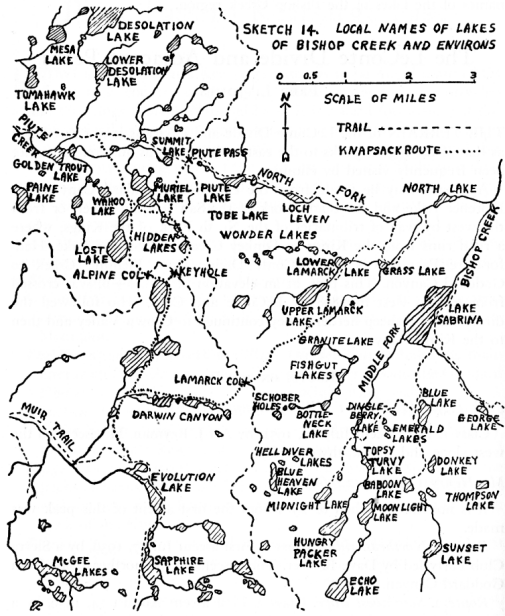
Sketch 14. Local Names of Lakes of Bishop Creek and Environs
| Online Library: | Title | Author | California | Geology | History | Indians | Muir | Mountaineering | Nature | Management |
Yosemite > Library > Climber’s Guide to the High Sierra > The LeConte Divide and Adjacent Peaks >
Next: Evolution & Black Divide • Contents • Previous: Piute Pass to Kearsarge Pass
THE TERRAIN of the LeConte Divide and environs is not as rugged as that of the higher peaks to the east; neither is it as austere. It has not been frequently visited by climbers.
Approach may be made from the east from Goddard Canyon, via Florence Lake and the South Fork of the San Joaquin River, or from the west by way of tributaries of the North Fork of the Kings, where a road runs from the Kings to Dinkey Creek and Shaver Lake. Hell-for-Sure Pass crosses the LeConte Divide from Fleming Creek to Goddard Canyon. This pass, at an elevation of 11,280+n, was crossed from east to west in 1898 by LeConte and Cory, who followed the directions of a sheep herder. They continued to Crown Valley and then to the Kings Canyon.
Peak 11,567 (11,600n; 1 NW of Mount Henry)
Class 1. First ascent July 10, 1951, by Art J. Reyman. He ascended the west slope and the northwest ridge.
Mt. Henry (12,197; 12,196n)
It is not known when or by whom the first ascent of this peak was made.
Route 1. Northeast ridge. Class 2. First ascent July 7, 1939, by a Sierra Club Party led by Dave Brower. They ascended the northeast side from Goddard Canyon.
Route 2. Southwest slope. Class 2. First ascent August 14, 1939, by a party of eight via the southwest slope from Fleming Creek.
Route 3. West slope. Class 2. First ascent August 29, 1940, by Bob Helliwell and Alden Bryant via the west slope from Blaney Meadows. The climb was described as long and tedious.
Route 4. North ridge. Class 3. First ascent July 10, 1951 by Art Reyman

[click to enlarge] Sketch 14. Local Names of Lakes of Bishop Creek and Environs |
Peak 12,100+ (12,154n; 1 SE of Mount Henry)
Class 2. First ascent July 10, 1951, by Art Reyman via the northwest ridge on a traverse from Mt. Henry.
Peak 12,023 (12,040n; 0.5 NW of Red Mountain)
Class 1. First ascent July 11, 1951, by Art Reyman. He ascended the south slope from Red Mountain Basin.
Red Mountain (11,933; 11,951n)
Class 1. First ascent July 12, 1898, by J. N. LeConte and C. L. Cory via the north side. It is class 1 from any side.
Peak 11,833 (11,760+n; 0.3 S of Hell-for-Sure Pass)
Class 2. First ascent July 11, 1951, by Art Reyman via the northwest ridge. It is a rough knife-edge climb from Hell-for-Sure Pass.
Peak 12,028 (12,034n; 1.5 S of Hell-for-Sure Pass)
Class 2. First ascent July 13, 1951, by Art Reyman via the northwest arÍte from Red Mountain Basin.
Peak 12,038 (12,011n; 1.5 SE of Hell-for-Sure Pass)
Class 2. First ascent July 13, 1951, by Art Reyman via the west ridge on a traverse from Peak 12,028.
Peak 12,254 (12,265n; 2.5 W of Mount Goddard)
Class 3. First ascent July 13, 1951, by Art Reyman via the west ridge. It is a knife-edge traverse from Peak 12,038. He descended into Lake Basin to the southwest.
Mount Reinstein (12,595; 12,604n)
No record of ascent is available, though Art Reyman believes he saw ,t cairn on its summit while on Peak 12,254.
Ward Mountain (10,395; 10,392n)
No record of ascent is available.
Mount Shinn (11,013; 11,020n)
First ascent August 8, 1925, by Francis A. Corey.
Peak 11,139 (11,148n; 2 W of Mount Henry)
Class 1. First ascent July to, 1951, by Art Reyman via the south and southeast slopes.
Fleming Mountain (10,750; 10,762n)
No record of ascent is available.
Peak 11,900+ (11,967n; 1.2 S of Hell-for-Sure Pass)
Class 1. First ascent July 12, 1951, by Art Reyman up the broad southwest slope.
Peak 11,275 (11,286n; 0.7 SE of Devils Punchbowl)
First ascent July 1, 1936, by W. M. Wyman and eight others. It is class 1 from the west, south or east slopes.
Peak 11,394 (11,398n; 1.5 SE of Devils Punchbowl)
Class 2. First ascent July 12, 1951, by Art Reyman along the north ridge from the saddle.
Maxson Dome (9,538)
First ascent August 15 (year not given, but it was prior to 1933 when the second ascent was made) by Waldo Knight and M. Kaye, a survey party for the San Joaquin Light and Power Co. It is class 1 from all sides.
Blackcap Mountain (11,159; 11,559n)
This is a USGS benchmark so it has been climbed.
Peak 10,624 (10,622n; 1 SW of Scepter Pass)
First ascent in 1951, by a USGS survey crew. Class 1 by west, south or east slopes.
Loper Peak (10,059)
This peak is a USGS benchmark so it has been climbed.
Finger Rock (9,500; 9,606n)
Castle Peak (10,668; 10,677n)
Volcanic Cone (9,180; 9,180n)
Crown Mountain (9,339; 9,318n)
Next: Evolution & Black Divide • Contents • Previous: Piute Pass to Kearsarge Pass
| Online Library: | Title | Author | California | Geology | History | Indians | Muir | Mountaineering | Nature | Management |
http://www.yosemite.ca.us/library/climbers_guide/leconte_divide.html