
[click to enlarge]
Devil’s Postpile, Devil’s Postpile National Monument, California. By William Hail
| Online Library: | Title | Author | California | Geology | History | Indians | Muir | Mountaineering | Nature | Management |
Yosemite > Library > François Matthes > The Devil’s Postpile and Its Strange Setting >
Next: Shepherd’s Crest • Contents • Previous: Kings River Canyon
|
[click to enlarge] Devil’s Postpile, Devil’s Postpile National Monument, California. By William Hail |
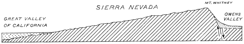
The Sierra Nevada, geologists tell us, consists essentially of one vast block of the earth’s crust that lies tilted toward the southwest, its northeastern edge elevated to form the crest line. The surface of the block, in general, slopes gently down to the Great Valley of California; the steep eastern side, exposed by the uplift, and in part, probably, by the subsidence of the earth blocks underlying Owens Valley and the Mono Basin, forms the imposing eastward-facing mountain front. A cross-section of the Sierra Nevada, accordingly, is like that shown, with vertical dimension somewhat exaggerated in Figure 6.
To an aviator soaring high above the range, its block form and its westerly slant are readily manifest, but to the mountaineer who, like a pygmy ant, crawls among the peaks and canyons of its surface, they are not obvious. Only from some of the higher summits on the main crest can he obtain a sufficiently comprehensive view to perceive the general form of the range. A great satisfaction it is, if you have the tilted-block concept in mind, to see it thus impressively demonstrated: Southwestward from Mount Dana or Mount Whitney, for instance, the range falls away gradually, its slope diversified by minor crests and ridges; to the northeast it drops off with amazing abruptness, to a depth of more than 6000 feet from the summit of Mount Dana, to a depth of 11,000 feet from Mount Whitney. To the northwest and the southeast the crest of the range extends as far as the eye can see, studded with boldly sculptured peaks. There is additional satisfaction in finding that, although the range is deeply furrowed by canyons and gulches, the divide between the easterly and westerly waters coincides in the main with the crest line.
If now you are fully convinced of the soundness of the tilted-block idea, and if perchance you are inclined to feel cocksure about it—even scientists occasionally have spells of cocksureness, ’tis only human—take yourself to the headwaters of the Middle Fork of the San Joaquin, the land of the Devil’s Postpile, the Mammoth Pass, and the Ritter Range. There the main crest of the Sierra Nevada sags down ignominiously to a low, flattish ridge, a third-rate feature of the sort that elsewhere in the Sierra Nevada would scarcely attract attention. No alpine “High Sierra” here, nor any amazing drop to the eastern foot of the range! From the Mammoth Pass the descent to the east is only 1500 feet, and from the saddle north of Mammoth Mountain, which is slightly lower than the pass, the descent is even less, and mostly in the form of a slope.
[click to enlarge] Figure 6 |
It is rather disturbing to one’s ideas of the nature of a tilted-block range, further, to discover that the canyon of the Middle Fork, immediately west of the saddle in the divide, is considerably lower than the country to the east. The altitude of Pumice Flat, north of the Devil’s Postpile, is 7700 to 7800 feet; that of Reds Meadow 7500 feet; the saddle in the divide is about 9300 feet, and the sloping plain directly east of the saddle averages over 8000 feet. To enhance the anomaly of the situation, there rises, west of the Middle Fork, an exceptionally bold, spectacular group of mountains that dwarfs the divide into insignificance —the group of which Banner Peak, Mount Ritter, and the Minarets are the principal summits. Over 13,000 feet in altitude, Mount Ritter towers more than a mile above Pumice Flat and the Devil’s Postpile, and fully 3800 feet above the saddle in the divide. Even Mammoth Mountain is outtopped more than 2000 feet. A profile line over the Ritter Range, across Pumice Flat, and over the divide, plotted without vertical exaggeration from the contour lines of the topographic map, turns out as shown in Figure 7.
How are these singular facts to be reconciled with the tilted-block form of the Sierra Nevada? Or is that form only a myth? Why is the main divide near the Devil’s Postpile so much lower than the Ritter Range? Why is not that lofty range, which connects at the north with Mount Lyell, itself the divide? How did the Middle Fork of the San Joaquin, which heads on the east flank of Banner Peak, succeed in cutting its canyon around the southern end of the Ritter Range? Why is the floor of its canyon in the vicinity of the Devil’s Postpile so much lower than the country east of the divide? And what, finally, is the real nature of the Devil’s Postpile? These are the questions that anyone who has visited the region is bound to ask himself.
It will be a comfort to those who still have a lingering faith in the tilted-block theory to note, in the first place, that though the crest of the Sierra Nevada in the vicinity of the Devil’s Postpile seems strangely low, nevertheless its lowest

[click to enlarge] Figure 7 |
What is this pumice, and whence did it come? It consists of small fragments and lumps of highly siliceous lava, literally steam-shredded, that were blown by spasmodic explosions from a series of craters to the east of the range. There are fully thirty of these craters, extending in a row from Mammoth Mountain northward to Mono Lake. Some are only a few hundred feet high, the largest more than 2000 feet. Their alignment (see Mount Lyell quadrangle) suggests strongly that they are associated with a great fracture, or a zone of fractures, in the crust of the earth. The bulk of the pumice naturally showered down immediately about the craters from which it was ejected, but the finer particles drifted some distance with the wind, and as a consequence there is a sprinkling of pumice over a considerable part of the Sierra Nevada. The Mammoth Pass and the divide for several miles to the north are most thickly covered, and Pumice Flat, as its name implies, is well supplied with it. Even at Reds Meadows and farther south along the Middle Fork there is a thin veneer of pumice. The dust it creates wears the skin off one’s fingers, as those who have camped in those parts have reason to remember.
The fractures in the earth, indicated by the row of craters mentioned, in all probability do not stop at the foot of the Sierra Nevada, but penetrate some distance into the body of the range. For not only does Mammoth Mountain, itself the remnant of an old volcano, stand in line with them, but so do the little Red Cones perched on the east side of the canyon of the Middle Fork, and Pumice Butte, north of Fish Creek. The famous hot spring near Reds Meadow, though somewhat west of the line, doubtless is connected with it.
A bubbling hot spring of this type, it is now realized, is essentially a volcanic phenomenon. It is fed in part by steam emanating from hot lava in process of crystallization, in part by surface water that has seeped down to great depths and has been heated by the steam. Water generated directly by igneous rocks is what geologists please to call “juvenile” water, in distinction to “meteoric” water, which falls upon the earth from the clouds. Let those who would make their ablutions in the hot spring bear this in mind. Perhaps they will feel rejuvenated as well as cleansed, if only as a result of the therapeutic value of the thought that the water is in part new-born, straight from Mother Earth.
Volcanism appears to have been active along the line of fractures at widely different dates in geologic history. The explosions of pumice represent but the latest chapter. They began toward the end of the Ice Age, and continued at intervals probably until fairly recent times. It is certain in any event that the pumice at Reds Meadow fell a long time after the Middle Fork Glacier had melted back to its source. Mammoth Mountain, on the other hand, dates back to preglacial time, and must be well over a million years old. By the long-continued disintegration of its volcanic rock it has long since lost its original crater form and has been reduced to a shapeless hump.
Intermediate between the formation of Mammoth Mountain and the eruptions from the pumice craters there occurred another remarkable volcanic outbreak: Right in the Mammoth Pass a fissure opened and let forth a flood of black basaltic lava. By far the greater part of this fluid material poured into the canyon of the Middle Fork and there spread out in an elongated mass that

[click to enlarge] Devil’s Postpile, Devil’s Postpile National Monument, California. By Cedric Wright |
The Middle Fork Glacier, when for the last time it readvanced, found this mass of basalt obstructing its path. Being about 1000 feet thick, it had no difficulty in overriding the obstruction. Moreover, the basalt, having cracked into columns by contraction while cooling, was readily quarried away by the glacier, column by column. During the thousands of years that the ice held sway, therefore, most of the basalt was removed and the canyon re-excavated nearly, in places all the way down to the granite. Only the more obdurate parts of the basalt mass were left standing. Of these the largest is that strange hump in the middle of the canyon, about 300 yards long and 200 feet high, which, because of the fancied resemblance of its tall, straight columns to posts stacked together in upright position, has been facetiously—and quite aptly—named the Devil’s Postpile.
A mere hummock in a landscape dominated by mile-high peaks, the Devil’s Postpile is nevertheless a feature of unusual interest to the scientist as well as to the layman. The columns that form its steep west front, facing the river, are exceptionally high, straight and cleancut; those at its southern end are remarkable for their curvature and their radial arrangement with respect to a center at the top of the pile. Strikingly beautiful, also, are the six-sided or five-sided end facets of the columns which in places still gleam with the polish that was imparted to them by the overriding glacier.
But now let us return to the interpretation of the larger features of the region. The full significance of the broad sag in the crest of the range is yet to be revealed. In all likelihood it is the mouth of an ancient valley which extended far to the eastward and whose stream emptied into the Middle Fork of the San Joaquin at that remote epoch when the Sierra block was not yet uptilted and when the waters from the country to the east still drained seaward across its surface. At that time, of course, the Middle Fork had not yet cut its profound canyon, but flowed in a relatively shallow valley slightly below the level of the sag and below the shoulders that now flank the canyon. It seems probable, furthermore, in view of the depth and breadth of the sag (Mammoth Mountain did not then exist), that the valley indicated by it was the pathway of a large river— indeed, of the main San Joaquin—and that that part of the present Middle Fork which pursues a southeasterly course from Thousand Island Lake to the Devil’s Postpile was merely a tributary of the master stream. The San Joaquin River, as we now know it, therefore appears to be a “beheaded” stream, its original upper course having been cut off by the uptilting of the Sierra block. Several other Sierra streams beside the San Joaquin, that now begin in gaps in the crest of the range, doubtless were similarly decapitated.
It is significant that, although the main San Joaquin flows southwestward, quite normally down the slope of the range, a number of its tributaries have southeasterly or northwesterly courses, in disregard of the general slant of the Sierra block. Not only the head of the Middle Fork, but the North Fork, Granite Creek, and Chiquito Creek have southeasterly courses; Fish Creek and the South Fork have northwesterly courses. All owe their trends to the constraining influence of more or less prominent ridges that themselves have a general northwest-southeast trend. A similar state of things is found in certain parts of the drainage basins of the Merced, Tuolumne, Kings, and Kaweah rivers. There is a definite reason for this. The area now occupied by the Sierra Nevada bore at an earlier time in geologic history—namely, during the Cretaceous period1—

[click to enlarge] Figure 8 |
The ancient mountain ranges of the Cretaceous period were not block ranges. They were carved from great wrinkles in the crust of the earth (Fig. 8) produced by the compression and folding of a series of strata that lay originally flat, having been deposited on the floor of the ocean—strata of sandstone, limestone, shale, and clay aggregating at least a mile in thickness. While the folding was in progress molten granite surged up and invaded the folds from below. Squeezed by the intense pressure and baked by the heat of the granite, the stratified rocks were “metamorphosed” to quartzite, marble, schist, and slate. Large bodies of these metamorphic rocks still remain in different parts of the Sierra Nevada, and by their contorted structure give evidence of the former existence of the mountain ranges, and even indicate their trend, their parallelism, and their general character, which must have been analogous to that of the present Appalachian Mountains. As a matter of fact the geologist finds incorporated in the Sierra block remnants of two such series of folded strata that differ widely in age, and thus he knows that two systems of mountains have in turn occupied the place of the present Sierra Nevada in times gone by.
The foothills and the choppy ridges through which the Merced River cuts its canyon below the Yosemite are composed largely of these metamorphic rocks. The mountains fronting upon the Mono Basin similarly are made of them. Some of the high crests that have inherited their northwesterly trends from the mountains of the Cretaceous period consist of smaller bodies. The Le Conte Divide, near the head of the South Fork of the San Joaquin, is a notable example. The Ritter Range is another but rather complicated example. The structure of the metamorphic rocks is most readily traced along its northeast base. The beds there stand vertical or at high angles, and have northwesterly trends. Gray schists and variously colored quartzites predominate. The upper canyon of the Middle Fork, from Pumice Flat to Thousand Island Lake, cuts lengthwise through these rocks and to them probably owes its position and its trend. The Ritter Range itself is composed in part of dark mottled rocks that represent ancient lavas metamorphosed out of all semblance to their former selves. Associated with these is a complex of dark igneous rocks that doubtless were injected in a molten state into the arch of one of the great upfolds of the ancient mountains. It is the exceedingly obdurate nature of these rocks that has permitted the Ritter Range to maintain its great height. The range notably terminates at the south where these rocks end. When, therefore, you climb Mount Ritter, you climb the core of one of the ancestral mountains that were formed more than a hundred million years before the present Sierra Nevada was uplifted.
Reprinted from Sierra Club Bulletin, 1930, pages 1-8.
1See footnote on page 97, and Appendix.—Ed.
Next: Shepherd’s Crest • Contents • Previous: Kings River Canyon
| Online Library: | Title | Author | California | Geology | History | Indians | Muir | Mountaineering | Nature | Management |
http://www.yosemite.ca.us/library/matthes/devils_postpile.html