[click to enlarge]
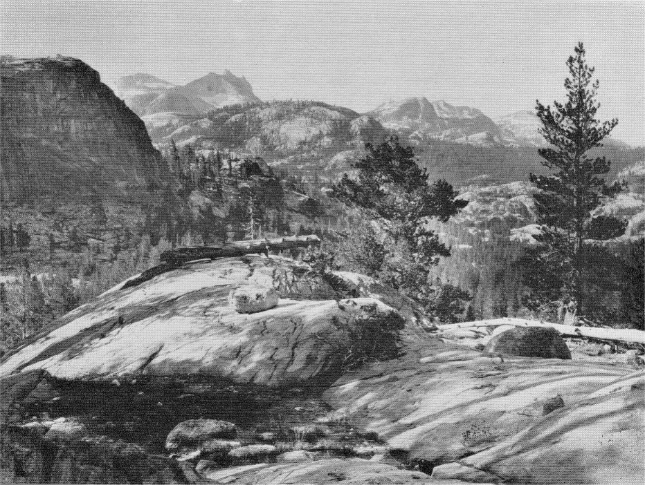
delta of the river at the head of the lake, and part of the Merced Canyon above. Yosemite
National Park, California. By François Matthes
| Online Library: | Title | Author | California | Geology | History | Indians | Muir | Mountaineering | Nature | Management |
Yosemite > Library > François Matthes > Merced Lake and Its Environment >
Next: Tokopah Valley • Contents • Previous: Tenaya Lake
The Upper Merced Canyon, in which Merced Lake is situated, may well be termed a lesser Yosemite, still unfinished. Like the main Yosemite Valley it is broadly U-shaped and has imposing walls of granite and waterfalls that leap down from lofty side valleys, but its floor is for the most part still unmade.
The level, parklike floor of the main Yosemite, which adds so much to the charm and livableness of that valley, was formed by the filling of a glacially excavated lake basin with sand and gravel brought down by the Merced River and Tenaya Creek. Those materials were not spread in layers on the floor of the basin but were deposited at the head of the lake in fan-shaped deltas, one at the mouth of each stream. The two deltas grew forward until they coalesced, and then a single large delta, built jointly by the two streams, advanced steadily until in the course of thousands of years it reached the lower end of the basin. As the late David Curry used to express it in his campfire talks: When the delta bumped its nose against the moraine at the foot of the lake, the filling was completed.
Merced Lake, though of much smaller dimensions, is the counterpart of ancient Lake Yosemite, except that it has no morainal dam at its lower end. It occupies a basin that was excavated in the rock floor of the canyon by the powerful Merced Glacier. Soundings have shown the basin to be about 80 feet deep. At the head of the lake the Merced River is even now building a delta of sand and gravel, and that delta, as it grows forward, will ultimately fill the lake and replace it with a level floor. The Sierra Nevada will then have gained one more Yosemite. But that event lies far in the future, for the delta front is advancing at an extremely slow rate—so slowly that the vegetation is amply able to keep up with its progress. Grass grows right up to the edge of the beach; willows and bushes follow within a few yards; and the forest trees are not far behind. Indeed, there is no danger that beautiful Lake Merced will diminish appreciably in size within our time or even in centuries to come.
That the lake lies really in a rock bowl and has no other kind of barrier is
evident from the nature of its outlet. There the water slips out over a smooth
barrier of extremely massive granite. So far apart are the fractures or “joints”
Washburn Lake, which lies 3 miles up valley from Merced Lake, is also a typical glacial lake occupying a rock basin enclosed by a barrier of massive granite. It has a sounded depth of 86 feet, but at its outlet the water is hardly two feet deep. The rock barrier is in plain view from the foot bridge that spans the outlet. Washburn Lake also has a delta at its head and already has lost about 500 feet of its original length by the forward growth of that delta.
It may seem strange that Merced Lake and Washburn Lake, though less than a mile long each, are still so largely unfilled, whereas ancient Lake Yosemite, which measured five and a half miles in length and probably at least 200 feet in depth, has been extinct for a long time. The reason is, in the main, that during the last glacial epoch the glaciers made two major advances separated by a long interval. Only the first advance penetrated the Yosemite Valley, while the second reached no farther than to the mouth of the Little Yosemite. The filling of Lake Yosemite therefore began many thousand years before Merced Lake and Washburn Lake were uncovered by the slowly melting ice. A second reason is that the Merced River and Tenaya Creek for a long time poured into Lake Yosemite large quantities of rock debris derived from the still extensive and active glaciers in the High Sierra, whereas the Merced River in its headwater reaches naturally carried only a small load.
Many other glacial lakes and lakelets in the upper Merced Basin are accessible from Merced Lake. Some of the most picturesque lie on the broad rock benches at the base of Merced Peak, Ottoway Peak, and Red Peak. Others lie strung like turquoise beads in the high-level canyon of the Lyell Fork and in the vicinity of the Isberg Pass. These are readily reached from the Isberg Pass Trail.
Of particular interest is Babcock Lake, which lies tucked away in a recess, two miles to the northeast of Merced Lake and nearly 2000 feet above it. In that recess the glacier that came southward from the twin valleys of Emerick and Fletcher creeks was deflected abruptly toward the east and at the turn developed tremendous excavating power. The granite there being traversed by rather widely spaced but strongly developed master joints, the glacier tore out great rectangular blocks and slabs, leaving the basin with remarkably straight sides, so that it now looks as if it had been sawed out with a cyclopean saw.
The depth which the Merced Glacier attained in the neighborhood of Merced Lake is indicated by the height of the lateral moraines (ridges of rock debris) which it left on the shoulders of the canyon. These moraines lie fully 2200 feet above Merced Lake and Washburn Lake. Those on the northeast side of the canyon are readily inspected from the Isberg Pass Trail, which parallels them for miles. As the canyon has suffered no further deepening since these moraines were laid down, there can be no doubt that the ice was about 2200 feet thick. When glacial conditions reached an optimum it probably was even somewhat thicker. The pressure which the Merced Glacier exerted upon its bed, due to its weight alone, must therefore have been fully 66 tons to the square foot. Added to that was the powerful forward thrust due to the gravitation of the ice mass and to the pressure of the many tributary glaciers that converged upon it from many different directions. The sum total of the Merced Glacier’s energy in the canyon must therefore have been very great, and the depth of the lake basins is thus readily accounted for.
Other evidences of the tremendous pressure which the Merced Glacier exerted upon its bed are to be seen in the grooves, striae, and polish which abound on the rock floor of the canyon. These fascinating products of glacial action are displayed in the vicinity of Merced Lake on an unusually grand scale, because of the prevalence of massive granite. The most impressive exhibits are along the old trail below Merced Lake, which is laid over the bare rock for long distances. The trail there is indicated by a row of stones, there being no other way of marking it across the featureless flats. Elsewhere in the Sierra Nevada, and in most other glaciated mountains, one may see glacier polish by the square yard, but here one beholds it literally by the acre. Even the walls of the canyon gleam with glacier polish up to a great height.
The polish was imparted to the granite by the fine rock dust which the grinding glacier carried in its bottom layers. The striae were produced by small angular fragments of hard rock, mostly quartz, and the grooves by large, heavy blocks that were dragged along by the slow-moving ice stream. Some of the grooves are from a quarter inch to a half inch in depth—truly amazing depths considering how hard and tough fresh, unweathered granite is.
Most amazing are the slanting grooves to be seen on the steep rock face to the north of the outlet of Merced Lake. There the ice rode up at a high angle to surmount a rock spur that projected into its channel. The grooves consequently slant upward, not downward, in the direction in which the ice moved. During the middle of the day these slanting grooves are inconspicuous, but in the early forenoon they stand out very prominently and are readily photographed.
Associated with the grooves, in many places on the floor of the canyon, are two kinds of curving fractures in the granite that afford impressive testimony of the glacier’s disrupting power. These are known as chatter marks and crescentic gouges. The chatter marks are the most abundant. They are fine cracks that are bowed upvalleyward and have a spread ranging from a few inches to a foot or more. They occur in series, spaced a fraction of an inch apart, each series astride of a more or less distinct groove. It is evident that they are tension cracks produced by the terrific pull exerted by the dragged boulders. Naturally they are most abundant in the more brittle kinds of rock, such as the aplite, a fine grained, cream colored rock that cuts across the granite here and there in so-called “dikes.” In some localities chatter marks are confined wholly to the aplite, dying out in the neighboring granite, which is tougher.
The crescentic gouges are bowed downvalleyward and although relatively uncommon, are very conspicuous wherever they do occur. They also are arranged in series, but there are seldom more than four or five in any one series, and they are spaced several inches or even more than a foot apart. They resemble the hoof marks of a gigantic horse—a horse that strode down the valley, stubbing its toes with terrific force so as to spall off flakes from the rock floor. These flakes were thickest at the outer curve and thinned inward to a knife edge. That the gouges are due to great pressure can not be doubted, but the precise manner in which they were made still remains a mystery.
A word about the origin of the granite, which is the prevailing country rock throughout the High Sierra. It is a material that welled up in a molten state from the depths of the earth and crystallized as it cooled. It did not, however, flow out upon the surface of the earth like lava, but remained confined in vast subterranean chambers beneath the outer crust. In the Sierra Nevada this crust consisted of strata of slate, schist, quartzite, and marble—the same materials that are still visible in the Merced Canyon below El Portal. These strata, originally flat lying, were buckled into huge wrinkles so as to give rise to a system of parallel mountain ridges with northwesterly trend. Those mountain ridges stood on the site of the present Sierra Nevada more than a hundred million years ago, but in the course of time they were completely worn away, their rocks, as they weathered and disintegrated, being carried away fragment by fragment, grain by grain, largely by washing rains and by brooks and rivers. Probably not less than two miles of rock have thus been removed by what geologists term the processes of erosion, and so the granite has been laid bare over large areas.
There were many upwellings of this molten material and as a consequence there are now many different types of granite in the Sierra Nevada. Two types occur in the upper Merced Basin—the Half Dome “quartz monzonite” and the Cathedral Peak granite. The former, named for Half Dome, makes up the lower part of the basin and all of the Little Yosemite region. The latter occurs chiefly in the Cathedral Range and in the country about the Tuolumne Meadows.
The two rocks are readily distinguished from each other by the fact that
the Half Dome granite is even textured, whereas the Cathedral Peak granite
contains unusually large crystals of white or pinkish feldspar—about two inches
in length and approximately rectangular in outline. As the granite disintegrates
these large feldspar crystals are liberated and remain lying on the ground.
Quantities of them may be picked up along the trail to the Tuolumne Pass and
|
Glacial boulders deposited on glacial-polished floor near the trail to Merced Lake.
By G. J. Young [click to enlarge] 
|
Of the older rocks that formerly overlay the granite and made up the bulk of the ancient mountain ranges already referred to, a few small patches remain on the peaks surrounding the upper Merced Basin. Of greatest interest, perhaps, is the mass of yellowish quartzite that is situated on the north spur of Mount Clark, east of Clark Canyon. This quartzite is an ancient sandstone that was altered—metamorphosed, as geologists say—by the intense pressure and heat to which it was subjected when the ancient mountains were created by the buckling and folding of their strata.
The massive granite in the upper Merced Canyon on which the glacier
polish is so extensively preserved is all of it Half Dome granite. Indeed, this
granite excels among the many different types of granitic rock in the Sierra
Nevada by its remarkably massive structure. As a rule granitic rocks are
traversed by many natural partings, or joints, as they are called, that develop
while the mass was solidifying. Additional fractures may be produced later
In reality this massive granite has not always been without fractures. The numerous dikes of aplite that traverse it in various directions show that it was once broken by many fissures. But into those fissures the hot, liquid aplite shot up and, as it crystallized, it sealed them tightly, uniting all the great fragments again into one solid, continuous mass. All along the upper Merced Canyon aplite dikes abound. They are readily recognized by their creamy or light buff color, which contrasts with the darker hue of the speckled granite. Some of them stand out slightly above the surface of the granite, because of their superior resistance to the weather. The dikes vary in width from a few inches to several feet; they even taper down to mere threads, showing that the molten aplite was an extremely fluid substance that could penetrate into the finest cracks.
In some places there are two sets of dikes, one cut through by the other. Frequently in such cases the older dikes appear offset by a few inches or even a foot, the great blocks of granite having been moved and dislocated. There is a certain fascination in the thought that by a little patient study one can today ascertain in some detail what manner of processes went on at a depth of two miles beneath the surface of the earth—under a mountain system that is no longer in existence—more than a hundred million years ago.
A peculiar feature of massive granite is that it tends to cast off thick, curving shells or plates from its surface. Such curving shells are to be seen on all the great domes of the Yosemite region, and on the walls of the Little Yosemite and the upper Merced Canyon. The explanation in all probability is that the granite, having crystallized under tremendous pressure, beneath miles of super-incumbent rock, tends to expand when freed from its load. In normally jointed granite the expansion is accommodated by slight movements on the intersecting fractures, but in massive granite it results in the bursting off of shells or plates approximately parallel to the exposed surface. Geologists term this process “exfoliation.”
The domes of the Yosemite region unquestionably owe their smoothly rounded forms to long-continued exfoliation, many successive shells having been cast off from their bodies in the course of time. It was believed formerly that the domes had been rounded by overriding glaciers; but that is now realized to be a fallacy, for some of the most typical domes—notably Sentinel and Half Dome—were never overtopped by the ice, as is now positively known from a detailed survey of the glacial moraines. The lower domes were overridden, but they are no rounder than the higher unglaciated ones.
Dome-like rock forms and smoothly curved cliffs predominate throughout the Little Yosemite, Lost Valley, and the upper Merced Canyon. They are to be interpreted as having been shaped in part by exfoliation, in part by glacial grinding. Doubtless all of them were heavily covered with shells before the Ice Age began. The old preglacial shells were, however, all plucked off during the first stage of glaciation, and the granite cores were probably ground and reshaped by the ice. Then, during the ensuing interglacial stage, exfoliation again proceeded undisturbed. The newly-formed shells were again removed during the next glacial stage; and so the two processes worked in alternation throughout the Ice Age, which in the Sierra Nevada comprised at least three stages of glaciation.
The rock forms as they now appear are still substantially as they were molded by the last glaciers. Over large areas, in fact, no new shells have been produced in all the time that has elapsed since the end of the Ice Age. When it is realized that that interval in the High Sierra was probably between 10,000 and 20,000 years long, the extreme slowness of the exfoliation process will be apparent.
See note on page 128.
Next: Tokopah Valley • Contents • Previous: Tenaya Lake
| Online Library: | Title | Author | California | Geology | History | Indians | Muir | Mountaineering | Nature | Management |
http://www.yosemite.ca.us/library/matthes/merced_lake.html