early glaciers
were born in
cirques such
as this one
above Gaylor
Lakes.
[click to enlarge]
—McCrary, NPS

| Online Library: | Title | Author | California | Geology | History | Indians | Muir | Mountaineering | Nature | Management |
Yosemite > Library > Tuolumne Meadows Trails > V. Gaylor Lakes and Vicinity >
Next: VI. Mono Pass • Contents • Previous: IV. Cathedral Lakes
|
Yosemite’s
early glaciers were born in cirques such as this one above Gaylor Lakes. [click to enlarge] —McCrary, NPS |
|
(2-easy all-day hike, 600 ft., 3 to 6 miles).
There are three Gaylor Lakes, lower, middle, and upper. In the same general basin occur two other lakes called Granite Lakes. By extending your hike by 3 miles it is possible to visit 4 of the 5 lakes. To do so would increase the difficulty, but the rewards are commensurate with the effort, as always. The Gaylor Lakes occur in meadows, are all stocked with fish, and are located in a grand space-wasting arena of granite and metamorphic rock. Leaving a busy entrance station you will find yourself, within an hour, in a wild, primitive haven. Plan to spend the day exploring, while the man of the family may fish successfully. From the entrance station to Middle Gaylor is a bare one mile.
Directions: Drive seven miles to Tioga Pass entrance station, parking on your left before the station house. At the parking lot you will find a sign indicating the fisherman’s trail up over the ridge about 600 feet above the road. The pass is about
|
Wind blown lodgepole pine above
Gaylor Lakes.
—McCrary, NPS [click to enlarge] 
|
Special Features: Whitebark pine trees become evident very soon up the trail (3, p. 19). Learn to identify this fine high altitude citizen. As you reach the top of the ridge, walk to the obvious division between the grey granites and the reddish metamorphic rock of the region. Look ahead at the granite ridge and, reversing your view, back at the range in the distance, where you will be able to make out the dividing line equally well through the region. Now notice the plants underfoot. You will find a yellow-brown flowered Indian paint brush growing in profusion on the northerly side of the ridge during middle July and August. Descend to the Middle Gaylor. To the right is a grand talus slope (broken blocks of granite). Here you may be favored by a scolding from a small animal, if you wait a few minutes in the early morning or late afternoon, known by four names: rock rabbit, whistling hare, pika, or cony (12, p. 61). By keeping to your right around the first lake, you will soon find an unsurpassed view of the Cathedral Range behind Tuolumne Meadows. Additionally, you will notice myriad wild flowers in season.
For the person who wishes to extend his hike even farther than indicated, move right around Pilot Peak to Upper Gaylor. At the outlet, face the prominence slightly to your left, and you will see a rock cabin. Hike toward it, keeping the lake on your right. Move beyond the cabin to the pass summit and you will discover the original exploratory mine shafts and miners’ buildings of the Great Sierra Consolidated Silver Mining Company (33).
|
Skyline from Middle Gaylor Lake
[click to enlarge] 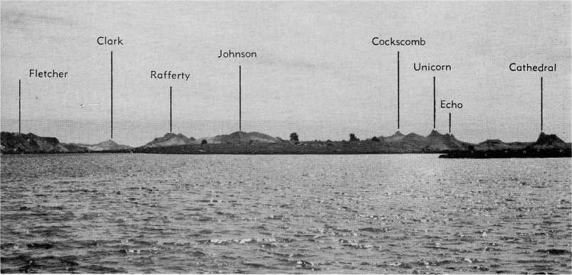
|
Next: VI. Mono Pass • Contents • Previous: IV. Cathedral Lakes
| Online Library: | Title | Author | California | Geology | History | Indians | Muir | Mountaineering | Nature | Management |
http://www.yosemite.ca.us/library/tuolumne_meadows_trails/gaylor_lakes.html