
[click to enlarge]
Niagara Falls (Courtesy of Niagara Falls Chamber of Commerce)
F. O. Seed
| Online Library: | Title | Author | California | Geology | History | Indians | Muir | Mountaineering | Nature | Management |
Yosemite > Library > Waterfalls > Waterfalls of Volume and Power >
Next: References • Contents • Previous: Other Waterfalls Classified As to Height
Discovered by Father Hennepin in 1678 this is, perhaps, the most famous cataract in the world. Millions have seen it but even to those who have not had that good fortune it is a symbol of tremendous power because of the thousands of words that have been written about it and the countless pictures of it that have been circulated throughout many years. It lies between Lake Erie and Lake Ontario, and is bisected by the Canadian-United States boundary. Near the brink the river is divided by Goat Island. Thus, but 6% of the water is diverted into that portion of the channel which leads to the American Falls, 167 feet high and about 1000 feet wide. The Canadian Falls, which carries the bulk of the water, is in the form of a great horseshoe 158 feet high and about 3000 feet wide. The total width, including Goat Island, is approximately one mile. Although not as high as either Victoria or Iguassu, Niagara surpasses both of these in volume, visibility and opportunity for general study and the charm of its aesthetic beauty is not marred by the aspect of its tremendous power. In addition, unlike either of its rivals, there is little fluctuation in volume through the seasons and in winter it is embroidered with icy lacework on a grand scale. (Ref. 26, 27, 28, 29, 37.)
|
[click to enlarge] Niagara Falls (Courtesy of Niagara Falls Chamber of Commerce) F. O. Seed |
[click to enlarge] Victoria Falls (Selchow, Black Star) |
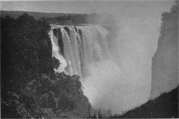
Discovered by David Livingstone in 1855, these great falls are located in the heart of Africa, about midway in the course of the Zambesi—“the greatest river in the world which casts itself in full volume over a precipice” (Nat’l Geog. Mag., July, 1926). At this point the mile wide, regal Zambesi, with a thunderous roar, abruptly hurls itself into the narrow confines of a deep chasm at right angles to the river’s course. The opposite side of this chasm is but 80 to 240 feet removed from the precipice over which the river pours and the churning waters send up clouds of spray which rise high into the air, and which can be seen for many miles. A narrow channel, little more than 100 feet wide, provides the only means of escape for the imprisoned waters which here are characterized by great rapids and whirlpools of tremendous force. Below this gorge the river changes direction several times as it rushes through a narrow canyon on its way to the Indian Ocean.
It is higher than either Niagara or Iguassu. At the brink of the falls the waters of the Zambesi are diverted into four channels by three islands, somewhat as Goat Island diverts Niagara’s waters. Although magnificent at any time the volume of the Zambesi varies greatly between the wet and dry seasons. During the flood period the clouds of spray are so dense that it is impossible to properly observe and appreciate the spectacle. (Ref. 26, 27, 28, 29, 37.)
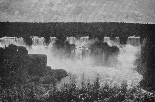
This, the third in the triumvirate of the world’s most powerful cataracts, although smaller in volume than either Niagara or Victoria, has greater breadth and by many is considered the most picturesque. It is found in the heart of South America on the Iguassu River at a point where the boundary of Brazil merges with that of Argentina. About one half mile wide some distance above the falls, the Iguassu River broadens as it approaches its great precipice which, including the numerous islands which divide the stream into a number of watercourses has a total width of nearly two miles. Generally speaking, however, there are two principal channels. The narrower and deeper forms the Brazilian and Union Falls, while the latter, after describing a great arc on the Argentine side, drops in a series of two leaps to form San Martin Falls. The greatest volume of water passes over Union Falls (213-230 feet high) which lies partly in Brazil and partly in Argentina. San Martin Island, which occupies a position comparable to that of Goat Island in the case of Niagara, forms the main division between the two principal sections of this cataract. Thus it prevents a comprehensive view of the entire fall from any one point. (Ref. 26, 27, 28, 29, 37.)
Although the information in this booklet is concerned with existing waterfalls, it is fitting that mention be made of a great cataract which in
[click to enlarge] Iguassu Falls (Ewing Galloway, New York) |
How was it formed and what caused its demise? Previous to the Ice Age the Columbia River followed a course essentially similar to that of the present day. Deeply imbedded in a broad valley it described a great arc in central Washington which has given rise to the term “big bend country” as applied to that area. With the advance of the ice cap to a point on the big bend plateau south of the upper arm of the Columbia’s course, that portion of the river’s valley was engulfed by the glacier. Streams having their origin in the ice cap raced southward across the big bend plateau to merge in the southern arm of the Columbia’s course before flowing west to the Pacific. The stream that formed the Grand Coulee and its great falls was the largest of these. With the retreat of the ice the original valley of the Columbia was vacated by the glacier, the waters deserted the temporary short cut across the big bend plateau and the Grand Coulee and its falls dried up and passed into history.
The Dry Falls, one of the most interesting geological phenomena in the world, is found about 25 miles south of the famous Coulee Dam, a short distance from Highway 49, in the State of Washington.

[click to enlarge] Dry Falls, State of Washington (Courtesy of Spokane Chamber of Commerce) |
Next: References • Contents • Previous: Other Waterfalls Classified As to Height
| Online Library: | Title | Author | California | Geology | History | Indians | Muir | Mountaineering | Nature | Management |
http://www.yosemite.ca.us/library/waterfalls/waterfalls_of_volume.html