| Online Library: | Title | Author | California | Geology | History | Indians | Muir | Mountaineering | Nature | Management |
Yosemite > Library > Heart of the Sierras > Madera Route >
Next: Chapter 20 • Index • Previous: Chapter 18
|
Go abroad
Upon the paths of Nature, and, when all Its voices whisper, and its silent things Are breathing the deep beauty of the world, Kneel at its simple altar, and the God Who hath the living waters shall be there.
—N. P. Willis.
|
|
Pleasures lie thickest where no pleasures seem;
There’s not a leaf that falls upon the ground But holds some joy, of silence or of sound, Some sprite begotten of a summer’s dream.
—Blanchard’s
Hidden Joys.
|
This route, like the Berenda, lies up the great valley of the San Joaquin, seven miles beyond the former starting-point, to Madera, a town probably of about five hundred inhabitants. We are now upon historic ground, as here the famous Fresno Indian Reservation was founded; and, about nine miles above where Madera now stands, was the place of general rendezvous for all the Indians gathered in, after the Mariposa Indian War of 1851-52; for the Indian Commission, and the officers and men forming the Mariposa Battalion. Then, it was one vast stretch of country without a building upon it, or any other sign of civilization—if we except those made necessary by the needs of reservation life—now it is dotted in all directions with farm-houses and gardens, orchards and vineyards, with cultivated fields, and succulent pastures, on every hand; with the Southern Pacific Railroad running through and among them. Let their enemies say what they may, these railroads are rapidly assisting development, and progress, wheresoever their iron bands may extend.
|
THE MADERA ROUTE.
From San Francisco, via Lathrop, Merced, Madera, Fresno Flats, and Mariposa
|
|||||
| STATIONS. | Distances in Miles. | ||||
| Between Consecutive Points. |
From San Francisco. |
To San Francisco. |
Altitude, in feet above Sea Level. |
||
|
By Railway. |
.... | .... | 185.03 | ||
| From San Francisco to— | |||||
|
Lathrop, junction of the Southern Pacific with the Central
Pacific Railroad (b c) |
94.03 | 94.03 | 91.00 | 28 | |
| Merced, on Southern Pacific Railroad (b c) | 58.00 | 152.03 | 33.00 | 171 | |
| Madera, on Southern Pacific Railroad (a b c d) | 33.00 | 185.03 | .... | 280 | |
|
By Carriage Road. | .... | .... | 95.35 | ||
| From Madera to— | |||||
| Adobe Station, Stitts’ (b c) | 9.25 | 9.25 | 86.10 | ||
| Mudgett’s Ranch (b c) | 9.25 | 18.50 | 76.85 | ||
| Green’s Ranch (b c d) | 6.50 | 25.00 | 70.35 | 1,100 | |
| Kron’s, Coarse Gold Gulch (b c d) | 13.50 | 38.50 | 56.85 | 2,085 | |
| Fresno Flats (b c) | 6.50 | 45.00 | 50.35 | 2,192 | |
| Bufford’s (b c) | 5.00 | 50.00 | 45.35 | 3,260 | |
| Board Ranch (b c d) | 8.00 | 58.00 | 37.36 | 4,639 | |
| Summit of Chowchilla Mountain | 3.60 | 61.60 | 33.76 | 5,005 | |
| Forks of road to Mariposa Big Tree Groves | 3.33 | 64.43 | 30.43 | 5,062 | |
| Big Tree Station, Clark’s (a b c d)* | 3.47 | 68.40 | 26.96 | 3,925 | |
| Eleven Mile Station (b c d) | 10.76 | 79.16 | 16.20 | 5,567 | |
| El Capitan Bridge, Yo Semite Valley | 12.57 | 91.73 | 3.63 | 3,926 | |
| Leidig’s Hotel, Yo Semite Valley (a b c d) | 2.56 | 97.29 | 1.07 | .... | |
| Cook’s Hotel, Yo Semite Valley (a b c d) | 0.30 | 97.59 | 0.77 | .... | |
| Barnard’s Hotel, Yo Semite Valley (a b c d) | 0.77 | 98.36 | .... | 3,934 | |
|
*From Big Tree Station (Clark’s) to and through the Mariposa Big Trees and back to station,
seventeen miles. |
|||||
|
RECAPITULATION. |
|||||
| By railway | 185.03 miles. | ||||
| By carriage road | 95.35 ” | ||||
| To Big Tree Groves and return | 17.00 ” | ||||
| ————— | |||||
| Total distance | 298.32 miles. | ||||
After the completion of the Southern Pacific Railroad through this section, the California Lumber Company was organized, for the purpose of tapping the extraordinary growth of timber that was found to exist in the Fresno Grove, and for bringing its lumber down to the market created by the railroad. Saw-mills were accordingly erected in that vicinity; but, as its great distance from market precluded the possibility of its successful delivery there by ordinary conveyance, a V flume was constructed, fifty-four miles in length, at an original cost of $375,000, for the purpose of floating it down. This will readily be seen at numerous points on the route. As soon as this was completed, the mills were put working to their fullest capacity; and lumber, to the extent of one hundred thousand feet per day, was started upon its meandering voyage to the depot. The business connected with this enterprise became the inception of the now prosperous town of “Madera"—Madera being Spanish for lumber. And for the purpose of meeting the wants of the people settling along the line of the railroad from here to New Mexico, the sugar and yellow pine, fir, and big tree wood, were converted into doors, blinds, sashes, etc. Here it may be said, in parenthesis, that the largest of the Big Trees, being found altogether too large for advantageous handling in lumber manufacturing, were allowed to remain undisturbed? Two hundred men are employed in this industry. They saw off the trees at the ground with the ordinary cross-cut saw, instead of chopping them down, as formerly.
There is a lumber yard of forty acres, through which there are roads and railroads in all directions, and to lumber piles of all sizes and kinds. Near the terminus of the flume it is divided into two branches, each of which is provided with a separate reservoir, into which the lumber is floated from the mountains; although most of it is removed directly from the flume, placed upon trucks, and then run upon tramways to the location desired. The waste-water, after being relieved of its cargo, is distributed in different directions, and sold for irrigation purposes.
This enterprise naturally formed the stimulating nucleus for the commencement of others; and farms and farm buildings sprung into existence; and with them the store and hotel, the blacksmith shop, and other creations of industrial development. So that now there are numerous stores, post-office, Wells, Fargo & Co’s. express office, a commodious hotel, saloons; and long lines of business places of all kinds needed in a thriving community, including a printing office and newspaper.
For many years Madera was the principal station on the Southern Pacific Railroad, for the departure of tourists for the Yo Semite Valley and Mariposa Big Tree Groves; but, since the construction of the Yo Semite branch railroad, from Berenda to Raymond, that business has naturally transferred thither. Owing, however, to its convenience of location, and the excellence of the mountain roads leading therefrom to the great sights beyond, Madera will continue to be the principal place of departure for all persons traveling by private teams. A short distance above this was once a very favorite place for rodeos* [* Rodeo is a Spanish word, generally applied to the place and annual gathering in of cattle and horses, for the purpose of counting and branding them.] and for rancheros.
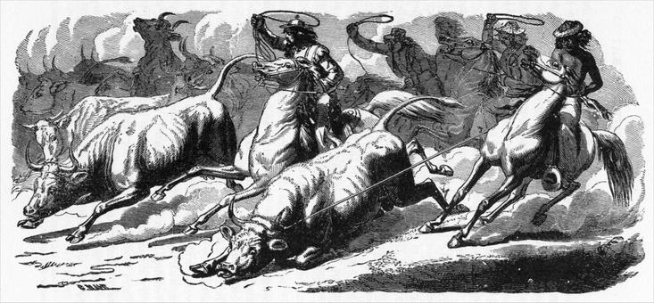
Before gold was discovered in California its main wealth seemed to consist in its cattle and horses, the former being slaughtered almost exclusively for their hides and tallow, which then formed about the only articles of export. As there were no fences in those days, all animals were allowed to roam wheresoever they chose; generally between defined bounds, as between rivers, or mountain ranges; and every spring their different owners, with their vaqueros (all well mounted), would sally out on a given day, scour the whole district assigned to them, and drive every animal found within it to the spot designated for the rodeo. Others would do the same for districts assigned to them, until every animal ranging at large was collected together.
This accomplished, all would assemble around a large camp-fire for social pleasures, and spend the remainder of the day in
|
|
| RANCHEROS LASSOING CATTLE. |
As our road lies over gently undulating hills near the Fresno River, we have frequent and refreshing glances of its willows and cottonwoods; and the bright green verdure of its meadow land, confessedly somewhat limited; with the V flume on its sinuous course at our side, bearing its freight of lumber down to the railroad.
Soon the white post oaks and numerous shrubs, begin to dot the landscape. Then we enter the cañon of Coarse Gold Gulch—one of the historic places of early days—and find the music of its gurgling waters, and the shadow of its alder and black oak trees, most pleasantly diverting until we reach the little village of the same name, and its hotel, where the inner man can be regaled and the outer man refreshed. Here we have attained an altitude of two thousand and eighty-five feet above the level of the sea.
After climbing a dividing ridge of the Fresno River, nearly a thousand feet above the gulch, we again descend to a pretty little hill-encompassed town, known everywhere as Fresno Flats. This is supported, mainly, by lumbering, farming, mining, and stock-raising. Being the business center of a number of small settlements around it, the principal street is fairly alive with teams, saddle-horses, bustling men and men of leisure; with the customary complement of Indians and dogs, found at nearly every foothill outpost of civilization throughout the State. More recently a number of gold-bearing quartz ledges have been found in the adjacent hills, which, when developed, will make an acceptable addition to the prosperity of the town. But,
“Onward, and upward, let our course be.”
Before advancing far upon our journey, we enter the glorious forests of the Sierra, which deservedly attract the wondering admiration of every traveler; these, diversified by broad openings and impressive glimpses of landscape, continue every foot of the way to Wawona. The highest portion of the Chow-chilla Range crossed upon this road is near the saw-mill at Fish Springs, which is five thousand one hundred and seven feet above sea level. This entire section is remarkably attractive to camping parties, desirous of exchanging the hot air of the plains for the deliciously cool atmosphere of the mountains, owing to the dense growth of its forests, the little patches of grassy meadows, and the leaping waters of Big Creek being literally alive with trout. Some families spend the whole summer here, at the Big Tree Groves, and on the mountains bordering the Yo Semite. The only detraction to this, as of other mountain fastnesses, is from the immense droves of sheep passing over, eating up every green thing (including beautiful lilies, and other flowering plants), and leaving a desert behind them. Nor is this all, for as neither deer nor any other game will feed after sheep, they naturally and necessarily seek other pastures. Then to this must be added the infamous practice of sheep-herders setting the forests on fire—the unprincipled return for being allowed to pasture their Rocks upon the public domain, free of every kind of charge. This route intersecting those of Berenda, and Mariposa, as before stated, at Wawona, they are thence necessarily continued conjointly.
Next: Chapter 20 • Index • Previous: Chapter 18
| Online Library: | Title | Author | California | Geology | History | Indians | Muir | Mountaineering | Nature | Management |
http://www.yosemite.ca.us/library/in_the_heart_of_the_sierras/19.html